IMAGES TAKEN NEAR TO
Kilmarnock Road, GLASGOW, G43 2DJ
Introduction
This page details the photographs taken nearby to Kilmarnock Road, G43 2DJ by members of the Geograph project.
The Geograph project started in 2005 with the aim of publishing, organising and preserving representative images for every square kilometre of Great Britain, Ireland and the Isle of Man.

There are currently over 7.5m images from over14,400 individuals and you can help contribute to the project by visiting https://www.geograph.org.uk
Image Map
Images are licensed for reuse under creativecommons.org/licenses/by-sa/2.0
Notes
- Clicking on the map will re-center to the selected point.
- The higher the marker number, the further away the image location is from the centre of the postcode.
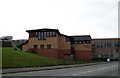
Image Listing (22 Images Found)
Images are licensed for reuse under creativecommons.org/licenses/by-sa/2.0
Image
Details
Distance
1
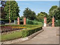
Kilmarnock Road entrance to Newlands Park
The Park sits in the middle of the suburb of Newlands. There are several small pedestrian entrances from the streets that bound it, plus these gates on the main thoroughfare of Kilmarnock Road.
Image: © Alec MacKinnon
Taken: 7 Jul 2013
0.05 miles
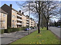
2
St Bride's Road
Early 20th century suburbia, Newlands.
Image: © Richard Webb
Taken: 9 Apr 2013
0.11 miles
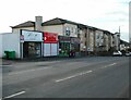
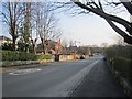
3

Shops, Riverford Road
M & H Hair and Beauty; Happy Garden (Chinese takeaway & home delivery); Natural Spice; and Kebab City.
Image: © Richard Sutcliffe
Taken: 15 Feb 2023
0.17 miles
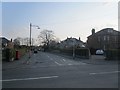
5
Road junction
The junction of the A77, Kilmarnock Road with Newlands Road and Riverford Road.
Image: © Richard Sutcliffe
Taken: 15 Feb 2023
0.17 miles
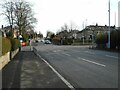
6
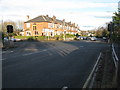
Crossroads in Newlands
Looking along Kilmarnock Road (A77) at the intersection with Nether Auldhouse Road (left) and Merrylee Road (right), both B762.
Image: © G Laird
Taken: 27 Nov 2012
0.17 miles
7
St Bride's Road
Newlands, buildings appeared on maps here in the early 20th century.
Image: © Richard Webb
Taken: 9 Apr 2013
0.17 miles
8
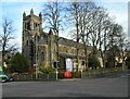
St Margaret of Scotland Scottish Episcopal Church
A Category B listed church http://portal.historicenvironment.scot/designation/LB33926. It was designed by Peter MacGregor Chalmers in 1895 and built in stages from 1908 to 1935.
Image: © Richard Sutcliffe
Taken: 15 Feb 2023
0.18 miles
10
Netherauldhouse Evangelical Church
Image: © Elliott Simpson
Taken: 19 Mar 2011
0.19 miles