IMAGES TAKEN NEAR TO
Ettrick Place, GLASGOW, G43 1UA
Introduction
This page details the photographs taken nearby to Ettrick Place, G43 1UA by members of the Geograph project.
The Geograph project started in 2005 with the aim of publishing, organising and preserving representative images for every square kilometre of Great Britain, Ireland and the Isle of Man.

There are currently over 7.5m images from over14,400 individuals and you can help contribute to the project by visiting https://www.geograph.org.uk
Image Map (Loading...)


Getting Data...Please wait
Leaflet Map data © OpenStreetMap
Images are licensed for reuse under creativecommons.org/licenses/by-sa/2.0
Notes
- Clicking on the map will re-center to the selected point.
- The higher the marker number, the further away the image location is from the centre of the postcode.
Image Listing (74 Images Found)
Images are licensed for reuse under creativecommons.org/licenses/by-sa/2.0
Image
Details
Distance
1
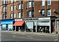
Newlands Home Bakery
Cafe and delicatessen, next door to Allied Surveyors Scotland, on Kilmarnock Road.
Image: © Richard Sutcliffe
Taken: 8 Sep 2023
0.02 miles
2
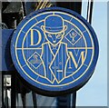
Sign for The Dapper Mongoose
Restaurant on Kilmarnock Road Image
Image: © Richard Sutcliffe
Taken: 8 Sep 2023
0.02 miles
3
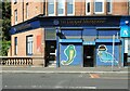
The Dapper Mongoose
Restaurant on Kilmarnock Road, Shawlands.
Image: © Richard Sutcliffe
Taken: 8 Sep 2023
0.02 miles
4
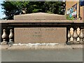
Macquisten Bridge
An inscription on the parapet of the Macquisten Bridge, which carries the A77, Kilmarnock Road over the White Cart Water. The bridge, which is Category C listed https://portal.historicenvironment.scot/designation/LB33925 was built in 1832 and widened in 1907 by James Gibson.
Image: © Richard Sutcliffe
Taken: 8 Sep 2023
0.03 miles
5
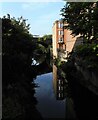
White Cart Water
The end of a tenement on Ettrick Place is reflected in the river. Pollokshaws East station is partly built over the bridge behind.
Image: © Richard Sutcliffe
Taken: 8 Sep 2023
0.03 miles
6
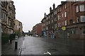
Kilmarnock Road, Shawlands
A wet morning in Shawlands. Looking south along the A77.
Image: © Richard Sutcliffe
Taken: 24 Oct 2015
0.03 miles
7
The Quaich
Public house on Coustonholm Road. The bridge behind carries the Cathcart Circle railway line.
Image: © Richard Sutcliffe
Taken: 3 Aug 2024
0.04 miles
8
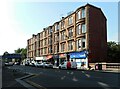
Tenement block, Kilmarnock Road
Tenements with shops and flats above.
Image: © Richard Sutcliffe
Taken: 8 Sep 2023
0.04 miles
9
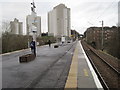
Pollokshaws East railway station, Glasgow
Opened in 1894 by the Cathcart District Railway and today is part of the Cathcart Circle.
View north west towards Shawlands and Glasgow.
Image: © Nigel Thompson
Taken: 19 Feb 2014
0.04 miles
10
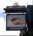
Sign for The Quaich
Sign for public house on Coustonholm Road Image A quaich is a traditional drinking vessel, usually used to drink whisky and brandy.
Image: © Richard Sutcliffe
Taken: 3 Aug 2024
0.04 miles