IMAGES TAKEN NEAR TO
Shawbridge Street, GLASGOW, G43 1QN
Introduction
This page details the photographs taken nearby to Shawbridge Street, G43 1QN by members of the Geograph project.
The Geograph project started in 2005 with the aim of publishing, organising and preserving representative images for every square kilometre of Great Britain, Ireland and the Isle of Man.

There are currently over 7.5m images from over14,400 individuals and you can help contribute to the project by visiting https://www.geograph.org.uk
Image Map
Images are licensed for reuse under creativecommons.org/licenses/by-sa/2.0
Notes
- Clicking on the map will re-center to the selected point.
- The higher the marker number, the further away the image location is from the centre of the postcode.
Image Listing (93 Images Found)
Images are licensed for reuse under creativecommons.org/licenses/by-sa/2.0
Image
Details
Distance
1
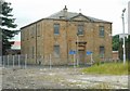
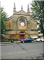
Pollokshaws Parish Church
Category B listed church, built in 1843, and still in use.
Image: © Richard Sutcliffe
Taken: 7 Jul 2017
0.00 miles
3
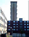
Towerblock on Shawbridge Street
Viewed from Pollokshaws Road.
Image: © Thomas Nugent
Taken: 19 Oct 2011
0.07 miles
5
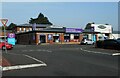
The Roundhouse Veterinary Hospital & Surgery
At Auldhouse Retail Park on Cogan Street. The name 'Roundhouse' comes from the old tollhouse nearby Image
Image: © Richard Sutcliffe
Taken: 8 Sep 2023
0.07 miles
6
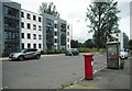
Flats on Shawbridge Street
Recently built flats. The pillar box is bostbox number G43 157D.
Image: © Richard Sutcliffe
Taken: 7 Jul 2017
0.07 miles
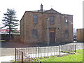
7
Former Pollokshaws United Free Church
Category B listed church, dating from about 1844 on Shawbridge Street. Now in use as a children's soft play area.
Image: © Richard Sutcliffe
Taken: 7 Jul 2017
0.07 miles
8
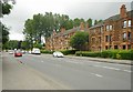
Tenements on Nether Auldhouse Road
Image: © Richard Sutcliffe
Taken: 7 Jul 2017
0.10 miles
9

The Tavern, Shawbridge Street
The local Police station is beyond.
Image: © Richard Sutcliffe
Taken: 7 Jul 2017
0.10 miles
10
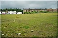
Waste ground, Shawfield Street
This area was the site of two tower blocks, 'Tassie' 93 Shawholm Crescent; and 'Shawholm' 232 Shawbridge Street; which were demolished between 2014 and 2016.
In the distance are the rear of tenements on Pollokshaws Road, and the Pollokshaws Methodist Church.
Image: © Richard Sutcliffe
Taken: 7 Jul 2017
0.10 miles