IMAGES TAKEN NEAR TO
Riverbank Street, GLASGOW, G43 1QG
Introduction
This page details the photographs taken nearby to Riverbank Street, G43 1QG by members of the Geograph project.
The Geograph project started in 2005 with the aim of publishing, organising and preserving representative images for every square kilometre of Great Britain, Ireland and the Isle of Man.

There are currently over 7.5m images from over14,400 individuals and you can help contribute to the project by visiting https://www.geograph.org.uk
Image Map
Images are licensed for reuse under creativecommons.org/licenses/by-sa/2.0
Notes
- Clicking on the map will re-center to the selected point.
- The higher the marker number, the further away the image location is from the centre of the postcode.
Image Listing (104 Images Found)
Images are licensed for reuse under creativecommons.org/licenses/by-sa/2.0
Image
Details
Distance
1
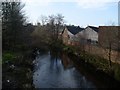
White Cart Water in Pollokshaws
From Riverford Road.
Image: © Stephen Sweeney
Taken: 25 Feb 2009
0.08 miles
2
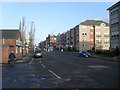
Flats on Riverford Road
Looking towards the Shawbridge Arcade.
Image: © Stephen Sweeney
Taken: 25 Feb 2009
0.10 miles
3
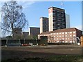
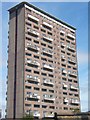
Shawbridge Highrise flats
From Ashtree Road.
Image: © Stephen Sweeney
Taken: 25 Feb 2009
0.10 miles
6
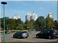
Morrisons' car park
The tower blocks in the distance are at Birness Drive.
Image: © Richard Sutcliffe
Taken: 8 Sep 2023
0.13 miles
7
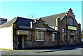
Former Salvation Army Hall
On Bengal Street, by Architect John H Hamilton (1851-1935) who also designed the nearby Sir John Maxwell Primary School. The building is now in use as a private nursery.
See also Image & Image
Image: © Thomas Nugent
Taken: 19 Oct 2011
0.14 miles
8
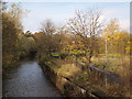
White Cart at Shawbridge Street
The picture was taken from the Shawbridge Street bridge over the White Cart river.
Image: © Alec MacKinnon
Taken: 1 Nov 2014
0.14 miles
9
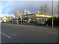
Morrison's Petrol Station
On Riverford Road in Pollokshaws.
Image: © Stephen Sweeney
Taken: 25 Feb 2009
0.14 miles
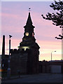
10
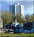
Remains of Pollokshaws Baths and Steamie
The baths and steamie (wash house) opened in 1908 and were last used as a private health club. The building appears to have been demolished quite recently. The clock tower beyond is all that remains of The Toonhoose, which was the original (1803) Pollokshaws Burgh Hall.
Image: © Thomas Nugent
Taken: 19 Oct 2011
0.14 miles