1
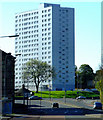
33 Cartcraigs Road
Smartly clad tower block.
Image: © Richard Webb
Taken: 9 Apr 2013
0.04 miles
2
Looking to highrise flat by Round Toll Roundabout
From Barrhead Road, heading onto the roundabout and Nether Auldhouse Road.
Image: © Stephen Sweeney
Taken: 12 Oct 2008
0.05 miles
3
Harriet Place
A long five-storey terrace of flats, dating from the 1970s.
Image: © Richard Sutcliffe
Taken: 7 Jul 2017
0.05 miles
4
Pollokshaws Tollhouse
Category B listed tollhouse [http://portal.historicenvironment.scot/designation/LB33915], dating from around 1820. It sits to one side of the large roundabout which forms the junction of Barrhead Road, Pollokshaws Road, Nether Auldhouse Road and Thornliebank Road.
Image: © Richard Sutcliffe
Taken: 7 Jul 2017
0.07 miles
5
Pollokshaws Tollhouse
Category B listed tollhouse [http://portal.historicenvironment.scot/designation/LB33915], dating from around 1820. It sits to one side of the large roundabout which forms the junction of Barrhead Road, Pollokshaws Road, Nether Auldhouse Road and Thornliebank Road.
Image: © Richard Sutcliffe
Taken: 7 Jul 2017
0.07 miles
6
Railway bridge, Barrhead Road
The bridge carries the Glasgow Central to Barrhead line.
Image: © Richard Sutcliffe
Taken: 7 Jul 2017
0.07 miles
7
Pollokshaws Tollhouse
Category B listed tollhouse [http://portal.historicenvironment.scot/designation/LB33915], dating from around 1820. It sits to one side of the large roundabout which forms the junction of Barrhead Road, Pollokshaws Road, Nether Auldhouse Road and Thornliebank Road.
Behind the roundabout are the high rise flats at 33 Cartcraigs Road.
Image: © Richard Sutcliffe
Taken: 7 Jul 2017
0.07 miles
8
Toll house, Pollokshaws
Built around 1800 when Pollokshaws was a Renfrewshire burgh. Pollokshaws was incorporated into Glasgow in 1912.
The toll house is currently situated in the middle of a roundabout, a situation similar to what is shown on the 1890's Ordnance Survey maps.
Image: © Richard Webb
Taken: 9 Apr 2013
0.07 miles
9
Cartcraig
The round toll house on the roundabout is all that remains of old Cartcraig. Viewed from outside Pollokshaws West railway station.
Image: © Thomas Nugent
Taken: 19 Oct 2011
0.08 miles
10
Round Toll House, Pollokshaws
In the centre of the Round Toll Roundabout.
Image: © Stephen Sweeney
Taken: 12 Oct 2008
0.08 miles


