IMAGES TAKEN NEAR TO
Wellmeadow Road, GLASGOW, G43 1JY
Introduction
This page details the photographs taken nearby to Wellmeadow Road, G43 1JY by members of the Geograph project.
The Geograph project started in 2005 with the aim of publishing, organising and preserving representative images for every square kilometre of Great Britain, Ireland and the Isle of Man.

There are currently over 7.5m images from over14,400 individuals and you can help contribute to the project by visiting https://www.geograph.org.uk
Image Map
Images are licensed for reuse under creativecommons.org/licenses/by-sa/2.0
Notes
- Clicking on the map will re-center to the selected point.
- The higher the marker number, the further away the image location is from the centre of the postcode.
Image Listing (14 Images Found)
Images are licensed for reuse under creativecommons.org/licenses/by-sa/2.0
Image
Details
Distance
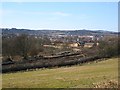
1
Kennishead Road
Links Kennishead and Pollokshaws. Pollokhead Wood on the right.
Image: © Richard Webb
Taken: 9 Apr 2013
0.14 miles
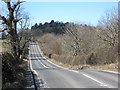
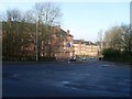
2
Busby Junction
The railway for East Kilbride leaves the Glasgow, Barrhead and Kilmarnock Joint Line here. There is a wedge of undeveloped land centred on Pollokshaws with a field here and a golf course across Kennishead Road.
Image: © Richard Webb
Taken: 9 Apr 2013
0.17 miles
3
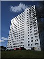
33 Cartcraigs Road
Smartly clad tower block.
Image: © Richard Webb
Taken: 9 Apr 2013
0.18 miles
4
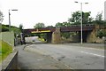
Railway bridge, Barrhead Road
The bridge carries the Glasgow Central to Barrhead line.
Image: © Richard Sutcliffe
Taken: 7 Jul 2017
0.18 miles
5
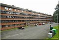
Harriet Place
A long five-storey terrace of flats, dating from the 1970s.
Image: © Richard Sutcliffe
Taken: 7 Jul 2017
0.19 miles
6
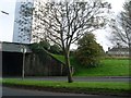
Looking to highrise flat by Round Toll Roundabout
From Barrhead Road, heading onto the roundabout and Nether Auldhouse Road.
Image: © Stephen Sweeney
Taken: 12 Oct 2008
0.19 miles
7
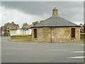
Pollokshaws Tollhouse
Category B listed tollhouse [http://portal.historicenvironment.scot/designation/LB33915], dating from around 1820. It sits to one side of the large roundabout which forms the junction of Barrhead Road, Pollokshaws Road, Nether Auldhouse Road and Thornliebank Road.
Image: © Richard Sutcliffe
Taken: 7 Jul 2017
0.21 miles
8
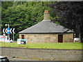
Pollokshaws Tollhouse
Category B listed tollhouse [http://portal.historicenvironment.scot/designation/LB33915], dating from around 1820. It sits to one side of the large roundabout which forms the junction of Barrhead Road, Pollokshaws Road, Nether Auldhouse Road and Thornliebank Road.
Image: © Richard Sutcliffe
Taken: 7 Jul 2017
0.21 miles
10
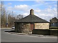
Toll house, Pollokshaws
Built around 1800 when Pollokshaws was a Renfrewshire burgh. Pollokshaws was incorporated into Glasgow in 1912.
The toll house is currently situated in the middle of a roundabout, a situation similar to what is shown on the 1890's Ordnance Survey maps.
Image: © Richard Webb
Taken: 9 Apr 2013
0.21 miles