IMAGES TAKEN NEAR TO
Riverford Court, GLASGOW, G43 1FB
Introduction
This page details the photographs taken nearby to Riverford Court, G43 1FB by members of the Geograph project.
The Geograph project started in 2005 with the aim of publishing, organising and preserving representative images for every square kilometre of Great Britain, Ireland and the Isle of Man.

There are currently over 7.5m images from over14,400 individuals and you can help contribute to the project by visiting https://www.geograph.org.uk
Image Map
Images are licensed for reuse under creativecommons.org/licenses/by-sa/2.0
Notes
- Clicking on the map will re-center to the selected point.
- The higher the marker number, the further away the image location is from the centre of the postcode.
Image Listing (87 Images Found)
Images are licensed for reuse under creativecommons.org/licenses/by-sa/2.0
Image
Details
Distance
1
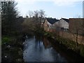
White Cart Water in Pollokshaws
From Riverford Road.
Image: © Stephen Sweeney
Taken: 25 Feb 2009
0.05 miles
2
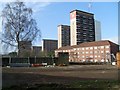
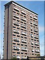
Shawbridge Highrise flats
From Ashtree Road.
Image: © Stephen Sweeney
Taken: 25 Feb 2009
0.13 miles
3
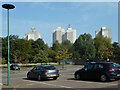
Morrisons' car park
The tower blocks in the distance are at Birness Drive.
Image: © Richard Sutcliffe
Taken: 8 Sep 2023
0.13 miles
4
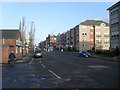
Flats on Riverford Road
Looking towards the Shawbridge Arcade.
Image: © Stephen Sweeney
Taken: 25 Feb 2009
0.13 miles
5
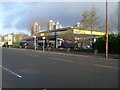
Morrison's Petrol Station
On Riverford Road in Pollokshaws.
Image: © Stephen Sweeney
Taken: 25 Feb 2009
0.13 miles
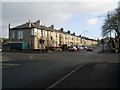
6
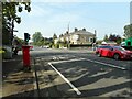
Auldhouse Road
At the junction with Riverford Road.
Image: © Richard Sutcliffe
Taken: 8 Sep 2023
0.15 miles
7
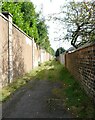
Back lane
Behind houses on Auldhouse Road.
Image: © Richard Sutcliffe
Taken: 8 Sep 2023
0.15 miles
8
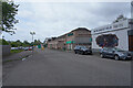
Newlandsfield Road
Looking along the road from outside Loks Restaurant.
Image: © Malcolm Neal
Taken: 14 May 2022
0.15 miles
10
Auldhouse Road housing
At Riverford Road.
Image: © Stephen Sweeney
Taken: 25 Feb 2009
0.16 miles