IMAGES TAKEN NEAR TO
Banchory Avenue, GLASGOW, G43 1EY
Introduction
This page details the photographs taken nearby to Banchory Avenue, G43 1EY by members of the Geograph project.
The Geograph project started in 2005 with the aim of publishing, organising and preserving representative images for every square kilometre of Great Britain, Ireland and the Isle of Man.

There are currently over 7.5m images from over14,400 individuals and you can help contribute to the project by visiting https://www.geograph.org.uk
Image Map
Images are licensed for reuse under creativecommons.org/licenses/by-sa/2.0
Notes
- Clicking on the map will re-center to the selected point.
- The higher the marker number, the further away the image location is from the centre of the postcode.
Image Listing (12 Images Found)
Images are licensed for reuse under creativecommons.org/licenses/by-sa/2.0
Image
Details
Distance
1
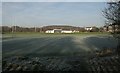
Hutchesons' Grammar Playing fields
Playing fields to the north of Eastwood Old Cemetery, from where the photograph was taken. This is Hutchesons' Grammar Auldhouse Sports Ground. The ground is laid out for rugby, although on this frosty day, nobody is playing. It's also used for cricket in the summer.
Image: © Richard Sutcliffe
Taken: 5 Jan 2017
0.14 miles
4
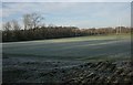
Hutchesons' Grammar Playing fields
Playing fields to the north of Eastwood Old Cemetery, from where the photograph was taken. This is Hutchesons' Grammar Auldhouse Sports Ground. The ground is laid out for rugby, although on this frosty day, nobody is playing. It's also used for cricket in the summer.
Image: © Richard Sutcliffe
Taken: 5 Jan 2017
0.20 miles
5
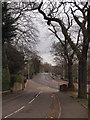
Thornliebank Road from Mansewood Road
The very short street in the foreground links Mansewood Road and Thornliebank Road, which recedes into the distance. We look from Mansewood Road. At any other, non-lockdown time, Thornliebank Road would be very busy with traffic on a Saturday morning.
Image: © Alec MacKinnon
Taken: 4 Apr 2020
0.21 miles
6
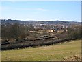
Busby Junction
The railway for East Kilbride leaves the Glasgow, Barrhead and Kilmarnock Joint Line here. There is a wedge of undeveloped land centred on Pollokshaws with a field here and a golf course across Kennishead Road.
Image: © Richard Webb
Taken: 9 Apr 2013
0.22 miles
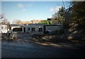
7
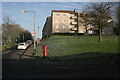
Flats on Barrmill Road
The pillar box is postbox number G43 1250D [http://www.geograph.org.uk/photo/5247510].
Image: © Richard Sutcliffe
Taken: 5 Jan 2017
0.23 miles
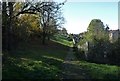
8
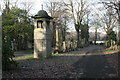
Eastwood Old Cemetery
The large granite memorial is to John Campbell, writer (1840-1903), and his family.
The cemetery is Category B listed.
Image: © Richard Sutcliffe
Taken: 5 Jan 2017
0.24 miles
9
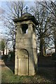
Eastwood Old Cemetery
A large granite memorial to John Campbell, writer (1840-1903), and his family.
The cemetery is Category B listed.
Image: © Richard Sutcliffe
Taken: 5 Jan 2017
0.24 miles
10
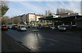
BP petrol station, Thornliebank Road
On the corner with Burnfield Road.
Image: © Richard Sutcliffe
Taken: 5 Jan 2017
0.25 miles