IMAGES TAKEN NEAR TO
Northwood Gate, GLASGOW, G43 1DQ
Introduction
This page details the photographs taken nearby to Northwood Gate, G43 1DQ by members of the Geograph project.
The Geograph project started in 2005 with the aim of publishing, organising and preserving representative images for every square kilometre of Great Britain, Ireland and the Isle of Man.

There are currently over 7.5m images from over14,400 individuals and you can help contribute to the project by visiting https://www.geograph.org.uk
Image Map
Images are licensed for reuse under creativecommons.org/licenses/by-sa/2.0
Notes
- Clicking on the map will re-center to the selected point.
- The higher the marker number, the further away the image location is from the centre of the postcode.
Image Listing (24 Images Found)
Images are licensed for reuse under creativecommons.org/licenses/by-sa/2.0
Image
Details
Distance
1
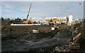
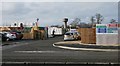
Construction site off Boydstone Road
Work is underway on the first phase of a new housing development. These will be 2, 3, 4 and 5 bedroom houses and 1 and 2 bedroom apartments. The former NS&I building in the distance will be demolished as part of the development.
Image: © Richard Sutcliffe
Taken: 13 Jan 2017
0.05 miles
2
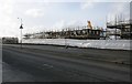
Houses under construction
The first houses under construction beside Boydstone Road of the new development, 'The Boulevard, Cowglen'.
Image: © Richard Sutcliffe
Taken: 3 Feb 2017
0.05 miles
3
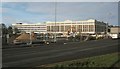
Former NS&I building, Glasgow
The National Savings and Investments headquarters on Boydstone Road, Glasgow closed in 2014, and demolition of the building is now underway. The whole site is to become a new housing development.
NS&I had occupied the site since the 1970s.
Image: © Richard Sutcliffe
Taken: 13 Jan 2017
0.11 miles
4
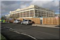
Former NS&I building, Glasgow
The National Savings and Investments headquarters on Boydstone Road, Glasgow closed in 2014, and demolition of the building is now underway. The whole site is to become a new housing development.
NS&I had occupied the site since the 1970s.
Image: © Richard Sutcliffe
Taken: 3 Feb 2017
0.11 miles
5
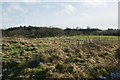
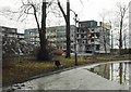
Rough ground east of Boydstone Road
Looking southeast from beside Boydstone Road towards the Kennishead flats.
Image: © Richard Sutcliffe
Taken: 3 Feb 2017
0.11 miles
6
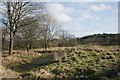
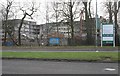
Rough ground east of Boydstone Road
Image: © Richard Sutcliffe
Taken: 3 Feb 2017
0.12 miles
7
Entrance to building site
Entrance to the site where new houses are being built as part of 'The Boulevard' housing estate. A small water tower is in the distance.
Image: © Richard Sutcliffe
Taken: 3 Feb 2017
0.13 miles
8
Demolition of water tower
A small water tower beside the former NS&I buildings being demolished. This view [http://www.geograph.org.uk/photo/5271261] taken a few days earlier shows the complete tower.
Image: © Richard Sutcliffe
Taken: 9 Feb 2017
0.14 miles
9
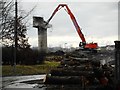
Demolition of NS&I building
Demolition of the National Savings and Investments building continues, to make way for a new housing development. Photographed from the side of Barrhead Road.
Image: © Richard Sutcliffe
Taken: 9 Feb 2017
0.16 miles
10
Demolition of NS&I building
Demolition of the National Savings and Investments building continues, to make way for a new housing development.
Image: © Richard Sutcliffe
Taken: 3 Feb 2017
0.16 miles