IMAGES TAKEN NEAR TO
Barrhead Road, GLASGOW, G43 1AY
Introduction
This page details the photographs taken nearby to Barrhead Road, G43 1AY by members of the Geograph project.
The Geograph project started in 2005 with the aim of publishing, organising and preserving representative images for every square kilometre of Great Britain, Ireland and the Isle of Man.

There are currently over 7.5m images from over14,400 individuals and you can help contribute to the project by visiting https://www.geograph.org.uk
Image Map
Images are licensed for reuse under creativecommons.org/licenses/by-sa/2.0
Notes
- Clicking on the map will re-center to the selected point.
- The higher the marker number, the further away the image location is from the centre of the postcode.
Image Listing (14 Images Found)
Images are licensed for reuse under creativecommons.org/licenses/by-sa/2.0
Image
Details
Distance
1
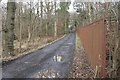
Road to Hippingstones
Road off Barrhead Road, leading to Hippingstones.
Image: © Richard Sutcliffe
Taken: 3 Feb 2017
0.06 miles
2
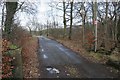
Road to Hippingstones
Road off Barrhead Road, leading to Hippingstones. The sign on the pole on the right says: 'PRIVATE PROPERTY KEEP OUT'.
Image: © Richard Sutcliffe
Taken: 3 Feb 2017
0.06 miles
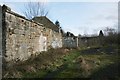
3
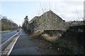
Broompark Farm
The ruins of Broompark Farm beside Barrhead Road (B762).
Image: © Richard Sutcliffe
Taken: 3 Feb 2017
0.10 miles
4
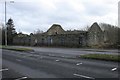
Broompark Farm
The ruins of Broompark Farm beside Barrhead Road (B762).
Image: © Richard Sutcliffe
Taken: 3 Feb 2017
0.10 miles
5
Broompark Farm
The ruins of Broompark Farm.
Image: © Richard Sutcliffe
Taken: 3 Feb 2017
0.10 miles
6
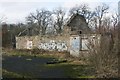
Graffiti, Broompark Farm
On the walls of the ruined farm buildings.
Image: © Richard Sutcliffe
Taken: 3 Feb 2017
0.10 miles
7

Graffiti, Broompark Farm
On the walls of the ruined farm buildings.
Image: © Richard Sutcliffe
Taken: 3 Feb 2017
0.10 miles
8
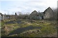
Broompark Farm
The ruins of Broompark Farm.
Image: © Richard Sutcliffe
Taken: 3 Feb 2017
0.12 miles
9
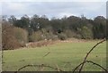
Broompark Farm
The ruins of Broompark Farm, seen from beside Boydstone Road.
Image: © Richard Sutcliffe
Taken: 3 Feb 2017
0.12 miles
10
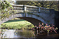
Pollok House Bridge
This bridge is dated 1768 and its design is attributed to the architect John Adam
Image: © Iain McKenzie
Taken: 25 Nov 2004
0.14 miles