
IMAGES TAKEN NEAR TO
Millbrae Road, GLASGOW, G42 9UP
Introduction
This page details the photographs taken nearby to Millbrae Road, G42 9UP by members of the Geograph project.
The Geograph project started in 2005 with the aim of publishing, organising and preserving representative images for every square kilometre of Great Britain, Ireland and the Isle of Man.

There are currently over 7.5m images from over14,400 individuals and you can help contribute to the project by visiting https://www.geograph.org.uk
Image Map
Images are licensed for reuse under creativecommons.org/licenses/by-sa/2.0
Notes
- Clicking on the map will re-center to the selected point.
- The higher the marker number, the further away the image location is from the centre of the postcode.
Image Listing (39 Images Found)
Images are licensed for reuse under creativecommons.org/licenses/by-sa/2.0
Image
Details
Distance
1

White Cart Water
Looking upstream from Millbrae Bridge.
Image: © Richard Sutcliffe
Taken: 16 Jul 2025
0.08 miles
3

Flair 'B' Wear
Former clothing shop on Tantallon Road. Now closed.
Image: © Richard Sutcliffe
Taken: 16 Jul 2025
0.10 miles
4

Sandstone tenements, Tantallon Road
Note the bicycle storage unit.
Image: © Richard Sutcliffe
Taken: 16 Jul 2025
0.11 miles
5
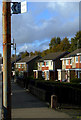
Earlspark Avenue
Near the lane which leads to Langside railway station.
Image: © Thomas Nugent
Taken: 30 Oct 2010
0.11 miles

7
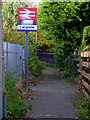
Lane leading to Langside railway station
The station underpass is to the left of the sign.
Image: © Thomas Nugent
Taken: 30 Oct 2010
0.12 miles
8
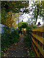
Lane leading to Langside railway station
Leads from Earlspark Avenue to the station which is to the left.
Image: © Thomas Nugent
Taken: 30 Oct 2010
0.12 miles
9
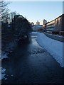
White Cart at Millbrae Road
The picture looks west along the White Cart from the bridge where Millbrae Road turns into Langside Drive. The winter afternoon's dying light reveals some of the topography of the immediate surroundings. The newly completed flood defences can be seen along the right-hand side.
Image: © Alec MacKinnon
Taken: 27 Nov 2010
0.12 miles
