IMAGES TAKEN NEAR TO
Ailsa Drive, GLASGOW, G42 9UL
Introduction
This page details the photographs taken nearby to Ailsa Drive, G42 9UL by members of the Geograph project.
The Geograph project started in 2005 with the aim of publishing, organising and preserving representative images for every square kilometre of Great Britain, Ireland and the Isle of Man.

There are currently over 7.5m images from over14,400 individuals and you can help contribute to the project by visiting https://www.geograph.org.uk
Image Map
Images are licensed for reuse under creativecommons.org/licenses/by-sa/2.0
Notes
- Clicking on the map will re-center to the selected point.
- The higher the marker number, the further away the image location is from the centre of the postcode.
Image Listing (43 Images Found)
Images are licensed for reuse under creativecommons.org/licenses/by-sa/2.0
Image
Details
Distance
1
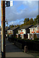
Earlspark Avenue
Near the lane which leads to Langside railway station.
Image: © Thomas Nugent
Taken: 30 Oct 2010
0.13 miles
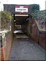
3
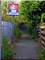
Lane leading to Langside railway station
The station underpass is to the left of the sign.
Image: © Thomas Nugent
Taken: 30 Oct 2010
0.15 miles
4
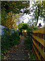
Lane leading to Langside railway station
Leads from Earlspark Avenue to the station which is to the left.
Image: © Thomas Nugent
Taken: 30 Oct 2010
0.15 miles
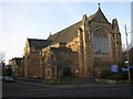
5
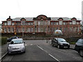
Battlefield School
Battlefield School, Carmichael Place from Dundrennan Road.
The school was designed by McWhannell, Rogerson & Reid and built in 1912. It was known as Queen's Park Junior Secondary until 1959, and then Battlefield Secondary School.
Image: © Dave Forrest
Taken: 20 Feb 2009
0.15 miles
6
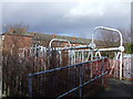
Pedestrian Bridge at Cartside Road, Glasgow
Image: © emma mykytyn
Taken: 24 Mar 2008
0.16 miles
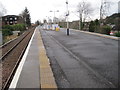
7
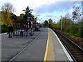
Langside railway station
Looking along the island platform towards Pollokshaws East station.
Image: © Thomas Nugent
Taken: 30 Oct 2010
0.16 miles
8
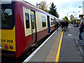
Langside railway station
Saturday afternoon Glasgow bound passengers board a three car electric train.
Image: © Thomas Nugent
Taken: 30 Oct 2010
0.17 miles
9
Langside railway station
The entrance to the underpass at the Earlspark Avenue side of the station. The station is on the Cathcart Circle line, between Cathcart and Pollokshaws East stations.
Image: © Thomas Nugent
Taken: 30 Oct 2010
0.17 miles
10
Langside railway station, Glasgow
Opened in 1894 by the Cathcart District Railway and today is part of the Cathcart Circle.
View north west towards Pollokshaws East and Glasgow.
Image: © Nigel Thompson
Taken: 19 Feb 2014
0.17 miles