IMAGES TAKEN NEAR TO
Battlefield Road, GLASGOW, G42 9JN
Introduction
This page details the photographs taken nearby to Battlefield Road, G42 9JN by members of the Geograph project.
The Geograph project started in 2005 with the aim of publishing, organising and preserving representative images for every square kilometre of Great Britain, Ireland and the Isle of Man.

There are currently over 7.5m images from over14,400 individuals and you can help contribute to the project by visiting https://www.geograph.org.uk
Image Map
Images are licensed for reuse under creativecommons.org/licenses/by-sa/2.0
Notes
- Clicking on the map will re-center to the selected point.
- The higher the marker number, the further away the image location is from the centre of the postcode.
Image Listing (163 Images Found)
Images are licensed for reuse under creativecommons.org/licenses/by-sa/2.0
Image
Details
Distance
1
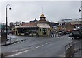
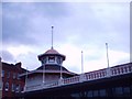
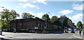
Battlefield Rest
A snippet in the menu tells us: " Originally used as a resting (and courting) place for tram travellers" (1914) - carefully restored, since 1994 trading as a bistro. (Delicious lunch with a glass of wine at a very reasonable rate, a welcome retreat from the grey March weather!)
Image: © Barbara Carr
Taken: 19 Mar 2013
0.01 miles
2
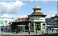
Battlefield Rest
A Category B Listed building, now in use as a bistro.
The Historic Scotland listing describes it as follows...
Opened 1915, as tramcar shelter. Edwardian baroque detail. Brick-built, faced in cream and green glazed tiles in stripes. Octagonal tower at south with shop at ground, pagoda-like timber stage above capped with wide eaves, and clocks on alternate faces in swagged panels; domed cupola and flagstaff. Central waiting room 5 bays with original seating; gabled to north with Glasgow coat of arms in aedicule at gable head. Public conveniences in semi-octagonal northern bay. Canopies now lost from side elevations.
Image: © Thomas Nugent
Taken: 27 Apr 2013
0.01 miles
3
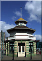
Battlefield Rest
A Category B Listed building, now in use as a bistro.
The Historic Scotland listing describes it as follows...
Opened 1915, as tramcar shelter. Edwardian baroque detail. Brick-built, faced in cream and green glazed tiles in stripes. Octagonal tower at south with shop at ground, pagoda-like timber stage above capped with wide eaves, and clocks on alternate faces in swagged panels; domed cupola and flagstaff. Central waiting room 5 bays with original seating; gabled to north with Glasgow coat of arms in aedicule at gable head. Public conveniences in semi-octagonal northern bay. Canopies now lost from side elevations.
Image: © Thomas Nugent
Taken: 27 Apr 2013
0.01 miles
4
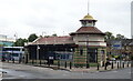
The Battlefield Rest
Continental bistro on Battlefield Road.
Originally a tram station and dating back to 1915.
Image: © JThomas
Taken: 14 Sep 2021
0.01 miles
6
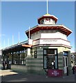
Battlefield Rest bistro
Housed in the Category B Listed http://portal.historicenvironment.scot/designation/LB32361 former tram shelter at the junction of Battlefield Road and Grange Road.
Image: © Thomas Nugent
Taken: 26 Sep 2020
0.02 miles
7
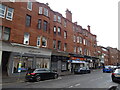
Shops on Sinclair Drive, Battlefield, Glasgow
Image: © JThomas
Taken: 14 Sep 2021
0.02 miles
8
Battlefield Rest and the Victoria Infirmary
See Image for more details about the Battlefield Rest building.
Image: © Thomas Nugent
Taken: 27 Apr 2013
0.02 miles
9
Langside Library
Built in 1913, this was the last of the city's Carnegie Libraries. Category B Listed http://portal.historicenvironment.scot/designation/LB32412 .
Image: © Thomas Nugent
Taken: 26 Sep 2020
0.02 miles
10
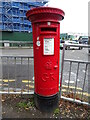
George V postbox on Battlefield Road
Postbox No. G42 572.
Image: © JThomas
Taken: 14 Sep 2021
0.03 miles