IMAGES TAKEN NEAR TO
Victoria Road, GLASGOW, G42 8YU
Introduction
This page details the photographs taken nearby to Victoria Road, G42 8YU by members of the Geograph project.
The Geograph project started in 2005 with the aim of publishing, organising and preserving representative images for every square kilometre of Great Britain, Ireland and the Isle of Man.

There are currently over 7.5m images from over14,400 individuals and you can help contribute to the project by visiting https://www.geograph.org.uk
Image Map
Images are licensed for reuse under creativecommons.org/licenses/by-sa/2.0
Notes
- Clicking on the map will re-center to the selected point.
- The higher the marker number, the further away the image location is from the centre of the postcode.
Image Listing (212 Images Found)
Images are licensed for reuse under creativecommons.org/licenses/by-sa/2.0
Image
Details
Distance
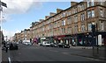
1
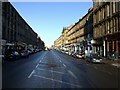
Victoria Road
Looking towards the city centre.
Image: © Thomas Nugent
Taken: 6 Jan 2010
0.02 miles
2
Victoria Road
Church and bank at the corner of Prince Edward Street.
Image: © Thomas Nugent
Taken: 6 Jan 2010
0.04 miles
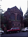
3
Bank of Scotland and the Tron Church
The entrance to the Tron Church, Queen's Park on Prince Edward Street, beside the Bank of Scotland. The church occupies part of the first floor, and also faces onto Victoria Road.
Image: © Richard Sutcliffe
Taken: 5 Mar 2017
0.04 miles
4
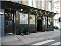
Victoria Bar
On Victoria Road. The art nouveau bar from 1903 is in a Category B listed http://portal.historicenvironment.scot/designation/LB32464 corner tenement dating from about 1880.
Image: © Richard Sutcliffe
Taken: 14 May 2022
0.04 miles
5
St Bride's Primary School
Built as the Strathbungo Public School in 1894. There are separate Boys' and Girls' gates at opposite ends. The Girls' gate can be seen here. Unusually the school was built incorporating a swimming pool at the lowest level. The school is Category B listed http://portal.historicenvironment.scot/designation/LB32428.
Image: © Richard Sutcliffe
Taken: 14 May 2022
0.05 miles
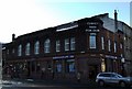
6
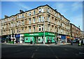
Victoria Road at Allison Street
The Paddy Power betting shop stands out on the ground floor of the corner tenement.
Image: © Richard Sutcliffe
Taken: 14 May 2022
0.05 miles
7
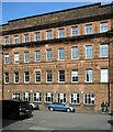
St Bride's Primary School
Built as the Strathbungo Public School in 1894. Unusually the school was built incorporating a swimming pool at the lowest level. The school is Category B listed http://portal.historicenvironment.scot/designation/LB32428.
Image: © Richard Sutcliffe
Taken: 14 May 2022
0.06 miles
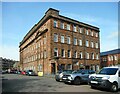
8
Madrassah Mosque
Former Church now the Madrassah Mosque 32-38 Dixon Avenue Glasgow G42 8EJ.
Image: © Alan Murray Walsh
Taken: 16 Sep 2008
0.06 miles
9
Craigie Street
St Bride's Primary School, built for Govan Parish School Board and dated 1894, is currently covered in scaffolding.
Image: © Richard Sutcliffe
Taken: 5 Mar 2017
0.06 miles
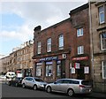
10
Victoria Road
Category B listed tenements with shops.
Image: © Richard Sutcliffe
Taken: 5 Mar 2017
0.06 miles