IMAGES TAKEN NEAR TO
Albert Road, GLASGOW, G42 8UE
Introduction
This page details the photographs taken nearby to Albert Road, G42 8UE by members of the Geograph project.
The Geograph project started in 2005 with the aim of publishing, organising and preserving representative images for every square kilometre of Great Britain, Ireland and the Isle of Man.

There are currently over 7.5m images from over14,400 individuals and you can help contribute to the project by visiting https://www.geograph.org.uk
Image Map
Images are licensed for reuse under creativecommons.org/licenses/by-sa/2.0
Notes
- Clicking on the map will re-center to the selected point.
- The higher the marker number, the further away the image location is from the centre of the postcode.
Image Listing (35 Images Found)
Images are licensed for reuse under creativecommons.org/licenses/by-sa/2.0
Image
Details
Distance
1
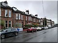
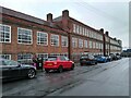
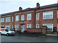
Houses on Albert Road
Beyond the houses is the southern range of the Category B range of the Category B listed http://portal.historicenvironment.scot/designation/LB32415 school, dating from 1936. It is the biggest secondary school in Scotland, with over 2,000 pupils and 150 teaching staff
Image: © Richard Sutcliffe
Taken: 20 Oct 2022
0.01 miles
2
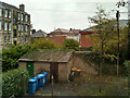
Sheds behind the tenements
Seen from a close window of a tenement on Eskdale Street. The sheds are in the 'back court' at the rear of the tenements. In the background is Holyrood Secondary School. The tenement on the left is on Dixon Road. This view was not visible a few months earlier. The large tree that grew beside the sheds was recently felled. Only the double stumps remain.
Image: © Richard Sutcliffe
Taken: 20 Oct 2022
0.02 miles
3
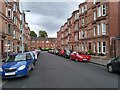
Eskdale Street
A quiet residential street. Looking towards Dixon Road.
Image: © Richard Sutcliffe
Taken: 3 Jul 2022
0.03 miles
4
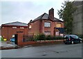
Janitor's Lodge, Holyrood Secondary School
The currently disused lodge is part of the Category B listed http://portal.historicenvironment.scot/designation/LB32415 Holyrood Secondary School.
Image: © Richard Sutcliffe
Taken: 20 Oct 2022
0.04 miles
5
Holyrood Secondary School
Southern range of the Category B http://portal.historicenvironment.scot/designation/LB32415 listed school, on Albert Road, dating from 1936. The school is the biggest secondary school in Scotland, with over 2,000 pupils and 150 teaching staff.
Image: © Richard Sutcliffe
Taken: 20 Oct 2022
0.04 miles
6
Govanhill Work Space
Offices and workspaces in the former Category B listed http://portal.historicenvironment.scot/designation/LB32467 New Bridgegate Church and hall on Dixon Road.
Image: © Richard Sutcliffe
Taken: 20 Oct 2022
0.06 miles
7
Corner of Cathcart Road
With Crosshill Grocers and Co-op funeral care in background
Image: © Paul Foster
Taken: 1 Oct 2021
0.06 miles
8
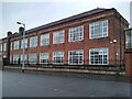
Holyrood Secondary School
North-western range of the Category B http://portal.historicenvironment.scot/designation/LB32415 listed school, on Dixon Road, dating from 1936. The school is the biggest secondary school in Scotland, with over 2,000 pupils and 150 teaching staff.
Image: © Richard Sutcliffe
Taken: 20 Oct 2022
0.06 miles
9
Holyrood Secondary School
Category B http://portal.historicenvironment.scot/designation/LB32415 listed school, on Dixon Road, dating from 1936. The school is the biggest secondary school in Scotland, with over 2,000 pupils and 150 teaching staff.
Image: © Richard Sutcliffe
Taken: 20 Oct 2022
0.07 miles
10
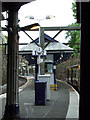
Crosshill railway station
Like many on the Cathcart Circle line, Crosshill station is in a cutting with an island platform.
Image: © Thomas Nugent
Taken: 1 Jun 2013
0.09 miles