IMAGES TAKEN NEAR TO
Albert Avenue, GLASGOW, G42 8RD
Introduction
This page details the photographs taken nearby to Albert Avenue, G42 8RD by members of the Geograph project.
The Geograph project started in 2005 with the aim of publishing, organising and preserving representative images for every square kilometre of Great Britain, Ireland and the Isle of Man.

There are currently over 7.5m images from over14,400 individuals and you can help contribute to the project by visiting https://www.geograph.org.uk
Image Map
Images are licensed for reuse under creativecommons.org/licenses/by-sa/2.0
Notes
- Clicking on the map will re-center to the selected point.
- The higher the marker number, the further away the image location is from the centre of the postcode.
Image Listing (228 Images Found)
Images are licensed for reuse under creativecommons.org/licenses/by-sa/2.0
Image
Details
Distance
1
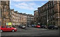
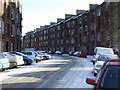
Albert Avenue
Seen from Queen's Drive. The corner of Queen's Park Govanhill Parish Church is on the left.
Image: © Richard Sutcliffe
Taken: 5 Mar 2017
0.01 miles
2
Albert Avenue
Part of Queen's Park Govanhill Parish Church can be seen at the end of the tenements.
Image: © Richard Sutcliffe
Taken: 5 Mar 2017
0.01 miles
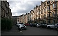
3
Albert Avenue
Viewed across Queens Drive, from Balvicar Drive.
Image: © Thomas Nugent
Taken: 6 Jan 2010
0.03 miles
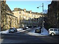
4
Maybank Street
Looking from Queen's Drive along Maybank Street to Albert Avenue.
Image: © Richard Sutcliffe
Taken: 5 Mar 2017
0.03 miles
5
Torrisdale Street
Viewed from Niddrie Road.
Image: © Thomas Nugent
Taken: 6 Jan 2010
0.04 miles
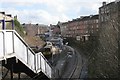
6
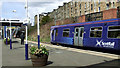
Queens Park railway station
On the Cathcart Circle line on the south side of the city. Class 314 train number 314 208 is at Platform 2, bound for Neilston.
Image: © Thomas Nugent
Taken: 27 Apr 2013
0.05 miles
7
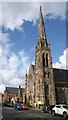
Queen's Park Govanhill Parish Church
A Category B listed church and adjacent hall. The church was built in 1873-5, the hall in 1879.
Image: © Richard Sutcliffe
Taken: 5 Mar 2017
0.05 miles
8
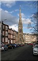
Queen's Park Govanhill Parish Church
A Category B listed church and adjacent hall, seen from Balvicar Drive. The church was built in 1873-5, the hall in 1879.
Image: © Richard Sutcliffe
Taken: 5 Mar 2017
0.05 miles
9
Queens Park Station
Seen from Niddrie Road. The station is on the Cathcart Circle, and was built for the Caledonian Railway in 1886. It is Category B listed.
Image: © Richard Sutcliffe
Taken: 5 Mar 2017
0.05 miles
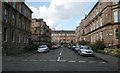
10
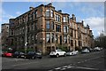
Corner of Albert Avenue and Queen's Drive
Late nineteenth century Category B listed tenements.
Image: © Richard Sutcliffe
Taken: 5 Mar 2017
0.05 miles