IMAGES TAKEN NEAR TO
Niddrie Square, GLASGOW, G42 8QE
Introduction
This page details the photographs taken nearby to Niddrie Square, G42 8QE by members of the Geograph project.
The Geograph project started in 2005 with the aim of publishing, organising and preserving representative images for every square kilometre of Great Britain, Ireland and the Isle of Man.

There are currently over 7.5m images from over14,400 individuals and you can help contribute to the project by visiting https://www.geograph.org.uk
Image Map
Images are licensed for reuse under creativecommons.org/licenses/by-sa/2.0
Notes
- Clicking on the map will re-center to the selected point.
- The higher the marker number, the further away the image location is from the centre of the postcode.
Image Listing (220 Images Found)
Images are licensed for reuse under creativecommons.org/licenses/by-sa/2.0
Image
Details
Distance
1
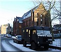
Niddrie Square
A Land Rover forward control vehicle (a 101FC or a 110FC), only made for the military. At the junction of Queens Drive.
Image: © Thomas Nugent
Taken: 6 Jan 2010
0.02 miles
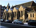
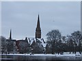
2
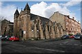
Queen's Park Baptist Church and hall
Category B listed church on Queen's Drive, built in 1886.
Image: © Richard Sutcliffe
Taken: 5 Mar 2017
0.03 miles
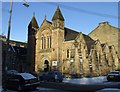
3
Former Seventh Day Adventist Church
Category B listed former church on Queen's Drive, originally built as the Swedenburgian New Jerusalem Church between 1886 and 1889. It was converted into a residential property in the 1990s.
Image: © Richard Sutcliffe
Taken: 5 Mar 2017
0.03 miles
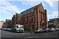
4
Queens Park Baptist Church
On Queens Drive at Niddrie Road.
Image: © Thomas Nugent
Taken: 6 Jan 2010
0.04 miles
5
Queens Park Baptist Church
The Niddrie Road side of the building.
Image: © Thomas Nugent
Taken: 6 Jan 2010
0.04 miles
7
Niddrie Square
On the edge of Queens Park at Queens Drive.
Image: © Thomas Nugent
Taken: 6 Jan 2010
0.04 miles
8
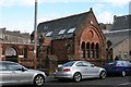
Former church building, Queen's Drive
Part of the former Seventh Day Adventist Church, originally built as the Swedenburgian New Jerusalem Church. This part of the building is dated 1888. It was converted into a residential property in the 1990s.
Image: © Richard Sutcliffe
Taken: 5 Mar 2017
0.04 miles
9
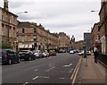
Strathbungo street scene
The picture looks north-east along Pollokshaws Road from close to the northern corner of Queen's Park.
Image: © Alec MacKinnon
Taken: 8 Aug 2015
0.04 miles
10
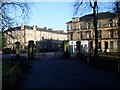
Gates at entrance to Queen's Park
Looking out from the park, towards Pollokshaws Road.
Image: © Stephen Sweeney
Taken: 28 Jan 2009
0.05 miles