IMAGES TAKEN NEAR TO
Niddrie Road, GLASGOW, G42 8NS
Introduction
This page details the photographs taken nearby to Niddrie Road, G42 8NS by members of the Geograph project.
The Geograph project started in 2005 with the aim of publishing, organising and preserving representative images for every square kilometre of Great Britain, Ireland and the Isle of Man.

There are currently over 7.5m images from over14,400 individuals and you can help contribute to the project by visiting https://www.geograph.org.uk
Image Map
Images are licensed for reuse under creativecommons.org/licenses/by-sa/2.0
Notes
- Clicking on the map will re-center to the selected point.
- The higher the marker number, the further away the image location is from the centre of the postcode.
Image Listing (268 Images Found)
Images are licensed for reuse under creativecommons.org/licenses/by-sa/2.0
Image
Details
Distance
2
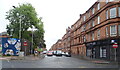
Pollokshaws Road
The A77, a busy route through the south of Glasgow.
Image: © Richard Webb
Taken: 9 Apr 2013
0.03 miles
3
Hutcheson's Grammar School
Primary grammar school in Glasgow's South Side.
Image: © Stephen Sweeney
Taken: 28 Jan 2009
0.03 miles
4
Nithsdale Drive / Pollokshaws Road, G41
Shows the location of Image
Image: © Mike Quinn
Taken: 21 Oct 2010
0.03 miles
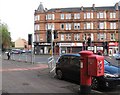
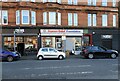
6
Shops on Pollokshaws Road
Showing position of Postbox No. G41 131.
See Image] for postbox.
Image: © JThomas
Taken: 14 Sep 2021
0.04 miles
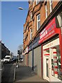
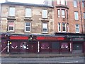
7
Shops on Pollokshaws Road
Crema (coffee shop), Human Relief Foundation (charity shop) and what appears to be Fumez (which may not actually have opened yet).
Image: © Richard Sutcliffe
Taken: 8 Sep 2023
0.04 miles
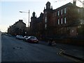
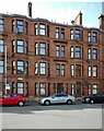
8
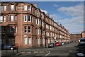
Tenements on Niddrie Road
At the junction with Allison Street.
Image: © Richard Sutcliffe
Taken: 5 Mar 2017
0.05 miles
9
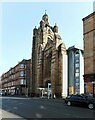
Former Strathbungo Parish Church
Only the facade and distinctive crown steeple remain of the former Strathbungo Parish Church, built in 1886 by J MacKissack (of MacKissack and Rowan) . The church closed in 1979 and became derelict. The main part of the church was demolished. In 2005 a number of residential flats were built behind the facade and tower https://en.wikipedia.org/wiki/Strathbungo_Parish_Church.
The building is Category B listed https://portal.historicenvironment.scot/designation/LB32397
Image: © Richard Sutcliffe
Taken: 8 Sep 2023
0.05 miles
10
32 Craigie Street
A red sandstone tenement - where my mother was born.
Image: © Richard Sutcliffe
Taken: 14 May 2022
0.05 miles