IMAGES TAKEN NEAR TO
Craigie Street, GLASGOW, G42 8NG
Introduction
This page details the photographs taken nearby to Craigie Street, G42 8NG by members of the Geograph project.
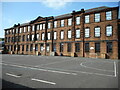
The Geograph project started in 2005 with the aim of publishing, organising and preserving representative images for every square kilometre of Great Britain, Ireland and the Isle of Man.

There are currently over 7.5m images from over14,400 individuals and you can help contribute to the project by visiting https://www.geograph.org.uk
Image Map
Images are licensed for reuse under creativecommons.org/licenses/by-sa/2.0
Notes
- Clicking on the map will re-center to the selected point.
- The higher the marker number, the further away the image location is from the centre of the postcode.
Image Listing (235 Images Found)
Images are licensed for reuse under creativecommons.org/licenses/by-sa/2.0
Image
Details
Distance
1
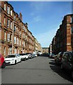
Craigie Street
Looking towards Calder Street.
Image: © Richard Sutcliffe
Taken: 14 May 2022
0.01 miles
2
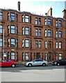
32 Craigie Street
A red sandstone tenement - where my mother was born.
Image: © Richard Sutcliffe
Taken: 14 May 2022
0.03 miles
3
Tenements on Calder Street
Looking east-southeast.
Image: © Richard Sutcliffe
Taken: 14 May 2022
0.03 miles
4
Hutcheson's Grammar School
Primary grammar school in Glasgow's South Side.
Image: © Stephen Sweeney
Taken: 28 Jan 2009
0.03 miles
5
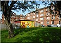
Electricity substation mural
The Craigie Street substation, located in a roughly rectangular open space between Craigie Street and Chapman Street has been decorated with a colourful mural.
Image: © Richard Sutcliffe
Taken: 14 May 2022
0.04 miles
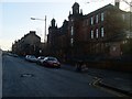
6
Victoria Road
Looking towards Queens Park.
Image: © Richard Sutcliffe
Taken: 14 May 2022
0.05 miles
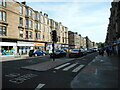
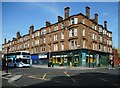
7
Tenements and shops, Victoria Road
Image: © Richard Sutcliffe
Taken: 14 May 2022
0.06 miles
8
Hutchesons' Grammar Junior School
Viewed from Calder Street (the main entrance is on the opposite side on Kingarth Street Image). Built as a girls' school in 1910-12, it is now the junior school for Hutchesons' Grammar. It is Category B listed http://portal.historicenvironment.scot/designation/LB33694.
Image: © Richard Sutcliffe
Taken: 14 May 2022
0.06 miles
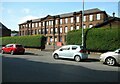
9
Hutchesons' Grammar Junior School
Viewed from Calder Street (the main entrance is on the opposite side on Kingarth Street Image). Built as a girls' school in 1910-12, it is now the junior school for Hutchesons' Grammar. It is Category B listed http://portal.historicenvironment.scot/designation/LB33694.
Image: © Richard Sutcliffe
Taken: 14 May 2022
0.06 miles
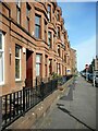
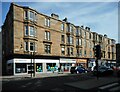
10
Red sandstone tenement
With shops at ground level. At the corner of Victoria Road and Calder Street. Locavore Grocery was previously a public house.
Image: © Richard Sutcliffe
Taken: 14 May 2022
0.06 miles