IMAGES TAKEN NEAR TO
Inglefield Street, GLASGOW, G42 7PP
Introduction
This page details the photographs taken nearby to Inglefield Street, G42 7PP by members of the Geograph project.
The Geograph project started in 2005 with the aim of publishing, organising and preserving representative images for every square kilometre of Great Britain, Ireland and the Isle of Man.

There are currently over 7.5m images from over14,400 individuals and you can help contribute to the project by visiting https://www.geograph.org.uk
Image Map
Images are licensed for reuse under creativecommons.org/licenses/by-sa/2.0
Notes
- Clicking on the map will re-center to the selected point.
- The higher the marker number, the further away the image location is from the centre of the postcode.
Image Listing (91 Images Found)
Images are licensed for reuse under creativecommons.org/licenses/by-sa/2.0
Image
Details
Distance
1
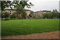
Govanhill Park
Looking across the park towards the yellow sandstone tenements on Inglefield Street.
Image: © Richard Sutcliffe
Taken: 30 Aug 2017
0.01 miles
2

Tenement walls, Coplaw Street
The very low railings hardly seem worth the effort.
Image: © Richard Sutcliffe
Taken: 30 Aug 2017
0.02 miles
3
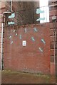
Wall between two tenements
This brick wall has been built between two sandstone tenements on Coplaw Street, and can just be seen in this view [http://www.geograph.org.uk/photo/5518681].
The wall incorporates an art work - the blue outlines of boots and shoes, and the metalwork above the wall incorporates a cobbler at work, wielding a hammer.
The graffitied sign on the wall (which rather spoils the artwork) reads:
Govanhill
DANGER
NO
CLIMBING
FENCE
Which is correct - it's a wall!
Image: © Richard Sutcliffe
Taken: 30 Aug 2017
0.02 miles
4
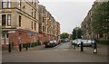
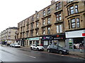
Preston Street
The tenements on the left are unusual in having a red sandstone ground floor, but yellow sandstone for the upper floors.
Image: © Richard Sutcliffe
Taken: 30 Aug 2017
0.02 miles
5
Cathcart Street, G42 (2)
Shows the location of Image
Image: © Mike Quinn
Taken: 16 Jun 2013
0.04 miles
6
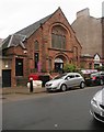
Big Noise, Coplaw Street
Forsyth House, a former church, dating from 1903, now operating as 'Big Noise' - a community based social transformation programme that aims to use intensive, immersive orchestral music making to foster confidence, teamwork, pride and aspiration in the children taking part – and across the wider community.
It is run by Sistema Scotland - a charity with a mission to create permanent social change in some of the most deprived communities in Scotland. The Govanhill facility (one of three operated by the charity) was set up in 2013. See [http://www.makeabignoise.org.uk/big-noise/] for more information.
Image: © Richard Sutcliffe
Taken: 30 Aug 2017
0.04 miles
7

Edward VIII postbox, Cathcart Road (near Preston Street), G42
Image: © Mike Quinn
Taken: 16 Jun 2013
0.05 miles
8

Edward VIII postbox, Cathcart Road (near Preston Street), G42 - royal cipher
See Image
Image: © Mike Quinn
Taken: 16 Jun 2013
0.05 miles
9
Cathcart Street, G42 (between Preston Street and Govanhill Street)
Shows the location of Image
Image: © Mike Quinn
Taken: 16 Jun 2013
0.05 miles
10
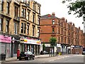
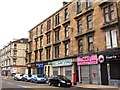
Shops on Cathcart Road
Showing position of Postbox No. G42 113.
See Image] for postbox.
Image: © JThomas
Taken: 14 Sep 2021
0.05 miles