IMAGES TAKEN NEAR TO
Calder Street, GLASGOW, G42 7NS
Introduction
This page details the photographs taken nearby to Calder Street, G42 7NS by members of the Geograph project.
The Geograph project started in 2005 with the aim of publishing, organising and preserving representative images for every square kilometre of Great Britain, Ireland and the Isle of Man.

There are currently over 7.5m images from over14,400 individuals and you can help contribute to the project by visiting https://www.geograph.org.uk
Image Map (Loading...)


Getting Data...Please wait
Leaflet Map data © OpenStreetMap
Images are licensed for reuse under creativecommons.org/licenses/by-sa/2.0
Notes
- Clicking on the map will re-center to the selected point.
- The higher the marker number, the further away the image location is from the centre of the postcode.
Image Listing (30 Images Found)
Images are licensed for reuse under creativecommons.org/licenses/by-sa/2.0
Image
Details
Distance
1
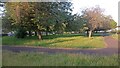
Bennan Square Park
It is often useful to read online 'memory lane' articles/discussions - most commonly found on Facebook or local news sites - to get a feel of the history of a place not noteworthy enough to have been covered by more official sources. However, memories are notoriously unreliable, and my research into this little park provided a good example of why these memories should always be treated with a bit of caution.
A Mr McInally, born in 1941 according to a 2019 piece in the Glasgow Times, 'remembers' when Bennan Square 'was just a big, empty green space'. In actual fact OS maps show that the street, along with its largely unaltered park, was fully built by at least 1936, five years before he was born!
The park is a bit of a throwback. On StreetMap it has the appearance of a football pitch in the middle of a street. This is because it has two opposing entrances halfway along its long sides and a path running between the two, as well as a path running round its perimeter. It's rather like British TV's most famous little park surrounded by houses - Albert Square in EastEnders.
There is no playground here, which may lie behind it being an 'ever-popular' place to live, according to the estate agents. The planning at the time did include a playground, which was - and still is - on a neighbouring street to the North. So in the interwar years the lucky residents of Bennan Square could read their daily newspapers in peace, having sent their children to the less popular street nearby. Not a bad idea really, though these days the adults are no doubt reading their phones instead.
One interesting recollection of Mr McInally - which I see no reason to dispute - is that swings often got tied up on a Saturday night to preserve the sanctity of the Sabbath!
Image: © Ian Dodds
Taken: 3 Jun 2023
0.07 miles
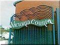
3
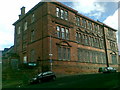
Former Victoria Primary School, Govanhill
Image: © Alex McGregor
Taken: 9 Sep 2010
0.17 miles
4
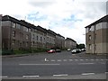
Jamieson Street
Residential street, Govanhill.
Image: © Richard Webb
Taken: 29 Jun 2011
0.18 miles
5
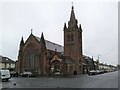
Govanhill Work Space
Offices and workspaces in the former Category B listed http://portal.historicenvironment.scot/designation/LB32467 New Bridgegate Church and hall on Dixon Road.
Image: © Richard Sutcliffe
Taken: 20 Oct 2022
0.18 miles
6
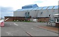
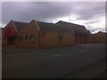
Closed factory, Aikinhead Road
It does not look long closed, the buddleia has yet to move in.
Image: © Richard Webb
Taken: 29 Jun 2011
0.18 miles
7
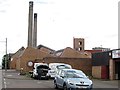
Car repairs, Polmadie
Small business premises, Polmadie. The two lums are part of a now closed waste incinerator.
Image: © Richard Webb
Taken: 29 Jun 2011
0.19 miles
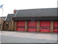
8
Polmadie
Polmadie Fire Station 560 Calder Street Glasgow G42 0PA
Image: © Alan Murray Walsh
Taken: 2 Sep 2008
0.19 miles