IMAGES TAKEN NEAR TO
Butterbiggins Road, GLASGOW, G42 7AL
Introduction
This page details the photographs taken nearby to Butterbiggins Road, G42 7AL by members of the Geograph project.
The Geograph project started in 2005 with the aim of publishing, organising and preserving representative images for every square kilometre of Great Britain, Ireland and the Isle of Man.

There are currently over 7.5m images from over14,400 individuals and you can help contribute to the project by visiting https://www.geograph.org.uk
Image Map
Images are licensed for reuse under creativecommons.org/licenses/by-sa/2.0
Notes
- Clicking on the map will re-center to the selected point.
- The higher the marker number, the further away the image location is from the centre of the postcode.
Image Listing (96 Images Found)
Images are licensed for reuse under creativecommons.org/licenses/by-sa/2.0
Image
Details
Distance
1
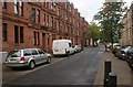
Inglefield Street
Red sandstone tenements on the west side of the street, yellow sandstone on the east side.
Image: © Richard Sutcliffe
Taken: 30 Aug 2017
0.03 miles
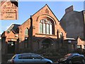
2

Sunshines on the Righteous
Elim Church Inglefield Street.
Image: © Lynn M Reid
Taken: 1 Mar 2008
0.03 miles
4
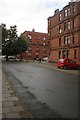
Coplaw Street
Bollards have turned this once through road into a cul-de-sac.
Image: © Richard Sutcliffe
Taken: 30 Aug 2017
0.06 miles
5
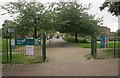
Entrance to Govanhill Park
The park is a small rectangular shaped area between Coplaw Street, Langside Road, Govanhill Street and Inglefield Street.
Image: © Richard Sutcliffe
Taken: 30 Aug 2017
0.07 miles
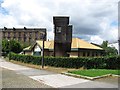
6
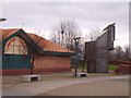
Govanhill Housing Association
Former chapel, dated 1903 (see inset), has now found a new use. There are numerous old churches and chapels in this area which have been given a new lease of life for both accommodation and business use.
Image: © Roger May
Taken: 13 Oct 2005
0.07 miles
7
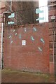
Wall between two tenements
This brick wall has been built between two sandstone tenements on Coplaw Street, and can just be seen in this view [http://www.geograph.org.uk/photo/5518681].
The wall incorporates an art work - the blue outlines of boots and shoes, and the metalwork above the wall incorporates a cobbler at work, wielding a hammer.
The graffitied sign on the wall (which rather spoils the artwork) reads:
Govanhill
DANGER
NO
CLIMBING
FENCE
Which is correct - it's a wall!
Image: © Richard Sutcliffe
Taken: 30 Aug 2017
0.07 miles
8

Tenement walls, Coplaw Street
The very low railings hardly seem worth the effort.
Image: © Richard Sutcliffe
Taken: 30 Aug 2017
0.07 miles
9
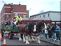
Heavy Horse Team
Fun Day at Larkfield Centre
Image: © Lynn M Reid
Taken: 15 Mar 2008
0.07 miles
10
Larkfield Centre
Community Centre, Govanhill.
Image: © Richard Webb
Taken: 29 Jun 2011
0.07 miles