IMAGES TAKEN NEAR TO
Aikenhead Road, GLASGOW, G42 0QJ
Introduction
This page details the photographs taken nearby to Aikenhead Road, G42 0QJ by members of the Geograph project.
The Geograph project started in 2005 with the aim of publishing, organising and preserving representative images for every square kilometre of Great Britain, Ireland and the Isle of Man.

There are currently over 7.5m images from over14,400 individuals and you can help contribute to the project by visiting https://www.geograph.org.uk
Image Map
Images are licensed for reuse under creativecommons.org/licenses/by-sa/2.0
Notes
- Clicking on the map will re-center to the selected point.
- The higher the marker number, the further away the image location is from the centre of the postcode.
Image Listing (15 Images Found)
Images are licensed for reuse under creativecommons.org/licenses/by-sa/2.0
Image
Details
Distance
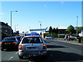
1
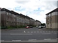
Jamieson Street
Residential street, Govanhill.
Image: © Richard Webb
Taken: 29 Jun 2011
0.04 miles
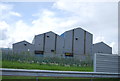
2
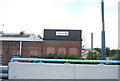
Closed factory, Aikinhead Road
It does not look long closed, the buddleia has yet to move in.
Image: © Richard Webb
Taken: 29 Jun 2011
0.05 miles
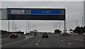
5
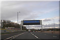
M74 westbound
Running alongside the railway at Polmadie.
Image: © Peter Bond
Taken: 3 Nov 2014
0.11 miles
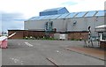
6
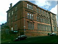
Former Victoria Primary School, Govanhill
Image: © Alex McGregor
Taken: 9 Sep 2010
0.13 miles

9
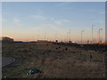
Disused land between the railway and motorway
The tall lampposts indicate the line of the M74 motorway.
Image: © Alec MacKinnon
Taken: 21 Jan 2017
0.20 miles