IMAGES TAKEN NEAR TO
Polmadie Road, GLASGOW, G42 0PH
Introduction
This page details the photographs taken nearby to Polmadie Road, G42 0PH by members of the Geograph project.
The Geograph project started in 2005 with the aim of publishing, organising and preserving representative images for every square kilometre of Great Britain, Ireland and the Isle of Man.

There are currently over 7.5m images from over14,400 individuals and you can help contribute to the project by visiting https://www.geograph.org.uk
Image Map
Images are licensed for reuse under creativecommons.org/licenses/by-sa/2.0
Notes
- Clicking on the map will re-center to the selected point.
- The higher the marker number, the further away the image location is from the centre of the postcode.
Image Listing (19 Images Found)
Images are licensed for reuse under creativecommons.org/licenses/by-sa/2.0
Image
Details
Distance
1
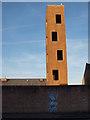
Tower of Polmadie Fire Station
The entrance to the fire station is on the far side, in Calder Street. On the Polmadie Street side it has quite a high wall which doubles here as a canvas.
Image: © Alec MacKinnon
Taken: 21 Jan 2017
0.02 miles
2
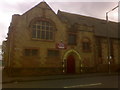
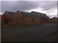
Church -Baptist
Zion Baptist Church, Calder Street Glasgow.
Image: © Alan Murray Walsh
Taken: 2 Sep 2008
0.03 miles
3
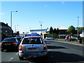
Calder Street
Looking along the road from outside the fire station towards a church and the former waste incineration plant.
Image: © Richard Webb
Taken: 29 Jun 2011
0.05 miles
4
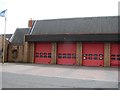
Polmadie
Polmadie Fire Station 560 Calder Street Glasgow G42 0PA
Image: © Alan Murray Walsh
Taken: 2 Sep 2008
0.06 miles
6
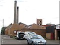
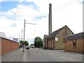
Car repairs, Polmadie
Small business premises, Polmadie. The two lums are part of a now closed waste incinerator.
Image: © Richard Webb
Taken: 29 Jun 2011
0.06 miles
7
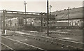
Polmadie loco sheds
The former LMS locomotive sheds, housing a variety of diesels.
Image: © Roger Cornfoot
Taken: Unknown
0.07 miles
8
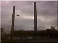
Polmadie
The twin chimneys of a now disused waste incinerator plant operated by Glasgow City Council.
In the 15th century this area was a medieval hospital ran by monk, it was beside a spring and a burn (rivulet) that flowed into the river Clyde.
The name Polmadie comes from the Gaelic - Poll Mac Dè: Poll = pool - Mac = of the sons - De’= God (pool of the sons of god).
Image: © Alan Murray Walsh
Taken: 2 Sep 2008
0.08 miles
9
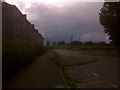
A derelict street in the soon to be replaced Oatlands
You can see the Polmadie twin chimneys of a now disused waste incinerator & several communications masts. The buildings on the right are a large railway maintenance depot for Virgin Trains, which is the most northerly train stabling and maintenance area on the West Coast Main Line.
Image: © Alan Murray Walsh
Taken: 2 Sep 2008
0.14 miles