IMAGES TAKEN NEAR TO
Lubas Place, GLASGOW, G42 0BW
Introduction
This page details the photographs taken nearby to Lubas Place, G42 0BW by members of the Geograph project.
The Geograph project started in 2005 with the aim of publishing, organising and preserving representative images for every square kilometre of Great Britain, Ireland and the Isle of Man.

There are currently over 7.5m images from over14,400 individuals and you can help contribute to the project by visiting https://www.geograph.org.uk
Image Map
Images are licensed for reuse under creativecommons.org/licenses/by-sa/2.0
Notes
- Clicking on the map will re-center to the selected point.
- The higher the marker number, the further away the image location is from the centre of the postcode.
Image Listing (4 Images Found)
Images are licensed for reuse under creativecommons.org/licenses/by-sa/2.0
Image
Details
Distance
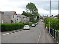
2
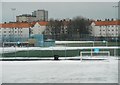
Football pitches at Toryglen Regional Football Centre
After snow. The flats in the background are on Kerrycroy Street and Kerrycroy Avenue.
Image: © Richard Sutcliffe
Taken: 5 Mar 2018
0.22 miles
3

St Brigid's Primary School
On Prospecthill Road.
Image: © Richard Sutcliffe
Taken: 20 Oct 2022
0.23 miles
4
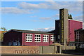
St Brigid's Primary School, Toryglen, Glasgow
Viewed from Prospecthill Road
Image: © Leslie Barrie
Taken: 9 Aug 2014
0.23 miles