IMAGES TAKEN NEAR TO
Maxwell Drive, GLASGOW, G41 5PR
Introduction
This page details the photographs taken nearby to Maxwell Drive, G41 5PR by members of the Geograph project.
The Geograph project started in 2005 with the aim of publishing, organising and preserving representative images for every square kilometre of Great Britain, Ireland and the Isle of Man.

There are currently over 7.5m images from over14,400 individuals and you can help contribute to the project by visiting https://www.geograph.org.uk
Image Map
Images are licensed for reuse under creativecommons.org/licenses/by-sa/2.0
Notes
- Clicking on the map will re-center to the selected point.
- The higher the marker number, the further away the image location is from the centre of the postcode.
Image Listing (28 Images Found)
Images are licensed for reuse under creativecommons.org/licenses/by-sa/2.0
Image
Details
Distance
1
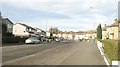
Maxwell Drive
A wide residential street just south of the railway line between Glasgow and Paisley.
Image: © Richard Webb
Taken: 6 Mar 2010
0.02 miles
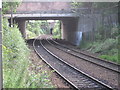
2
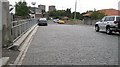
Setts, Gower Street
Setts on a bridge over the railway.
Image: © Richard Webb
Taken: 24 Sep 2008
0.09 miles
3
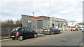
Gower Street
Fast food outlet on a bridge over the railway to Paisley Canal Street.
Image: © Richard Webb
Taken: 6 Mar 2010
0.10 miles
4
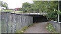
Path beside the M77
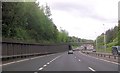
Path linking Gower Street with a footbridge over 15 lanes of motorway. Here the M77 is leaving the M8 for Ayrshire.
Image: © Richard Webb
Taken: 24 Sep 2008
0.14 miles
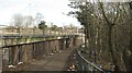
5
Bellahouston railway station (site), Glasgow
Opened in 1885 by the Glasgow & South Western Railway on its line from Glasgow to Elderslie via Paisley Canal, this station (between the bridges) closed in 1964. View north east from the present Dumbreck station, which replaced it.
Image: © Nigel Thompson
Taken: 28 Jul 2012
0.14 miles
6
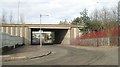
Gower Terrace
The name suggests that this was once a residential street. Today it is an underpass leading beneath the M77 to Bellahouston Academy (visible through the bridge).
Image: © Richard Webb
Taken: 6 Mar 2010
0.17 miles
7
Path beside the M77
The path runs beside the M77 where it leaves the M8. There is a lot of litter here mainly provided by outdoor drinkers. Pleasantly quiet on a Saturday morning though.
A certain "cider" produced in Hereford seems to be the most popular tipple.
Image: © Richard Webb
Taken: 6 Mar 2010
0.18 miles
8
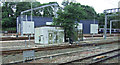
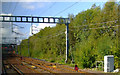
Shields Depot
A passenger train maintenance depot by the Glasgow-Paisley Gilomur St and Glasgow-Paisley Canal lines.
Image: © Thomas Nugent
Taken: 21 Jul 2012
0.19 miles
10
Line closed for engineering works
This is the Glasgow to Paisley Gilmour Street line, viewed from a train exiting the Paisley Canal line at Shields Junction. The line is closed for the addition of a third track from here to Arkleston Junction, just east of Paisley Gilmour Street station. Note the stop signs on the tracks.
Image: © Thomas Nugent
Taken: 24 Sep 2011
0.19 miles