IMAGES TAKEN NEAR TO
Aytoun Road, GLASGOW, G41 5HW
Introduction
This page details the photographs taken nearby to Aytoun Road, G41 5HW by members of the Geograph project.
The Geograph project started in 2005 with the aim of publishing, organising and preserving representative images for every square kilometre of Great Britain, Ireland and the Isle of Man.

There are currently over 7.5m images from over14,400 individuals and you can help contribute to the project by visiting https://www.geograph.org.uk
Image Map
Images are licensed for reuse under creativecommons.org/licenses/by-sa/2.0
Notes
- Clicking on the map will re-center to the selected point.
- The higher the marker number, the further away the image location is from the centre of the postcode.
Image Listing (34 Images Found)
Images are licensed for reuse under creativecommons.org/licenses/by-sa/2.0
Image
Details
Distance
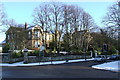
1
Gardens of a house on Nithsdale Road
Image: © Stephen Sweeney
Taken: 25 Feb 2009
0.10 miles
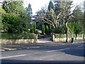
2
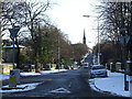
Aytoun Road
Twenty's Plenty east of St Andrews Drive.
Image: © Thomas Nugent
Taken: 6 Jan 2010
0.10 miles
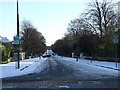
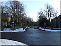
4
Albert Drive
Looking east from St Andrews Drive.
Image: © Thomas Nugent
Taken: 6 Jan 2010
0.12 miles
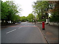
5
Nithsdale Road
Looking west across St Andrews Drive.
Image: © Thomas Nugent
Taken: 6 Jan 2010
0.12 miles
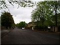
6
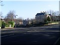
St John's Road, Pollokshields
Residential street in the south of Glasgow.
Image: © Stephen Sweeney
Taken: 25 Feb 2009
0.12 miles
7
Houses on St John's Road, Pollokshields
Showing position of Postbox No. G41 211.
See Image] for postbox.
Image: © JThomas
Taken: 14 Sep 2021
0.12 miles
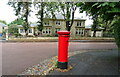
8
Pillar box on St John's Road, Pollokshields
Postbox No. G41 211.
See Image] for context
Image: © JThomas
Taken: 14 Sep 2021
0.14 miles
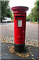
9
Letter Box Nithsdale Road
Junction with St Andrew's Drive in background.
Image: © Gordon Dowie
Taken: 4 May 2010
0.15 miles