IMAGES TAKEN NEAR TO
Nithsdale Road, GLASGOW, G41 5AW
Introduction
This page details the photographs taken nearby to Nithsdale Road, G41 5AW by members of the Geograph project.
The Geograph project started in 2005 with the aim of publishing, organising and preserving representative images for every square kilometre of Great Britain, Ireland and the Isle of Man.

There are currently over 7.5m images from over14,400 individuals and you can help contribute to the project by visiting https://www.geograph.org.uk
Image Map
Images are licensed for reuse under creativecommons.org/licenses/by-sa/2.0
Notes
- Clicking on the map will re-center to the selected point.
- The higher the marker number, the further away the image location is from the centre of the postcode.
Image Listing (42 Images Found)
Images are licensed for reuse under creativecommons.org/licenses/by-sa/2.0
Image
Details
Distance
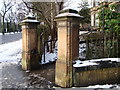
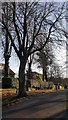
4
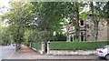
Leafy Dumbreck
Nithsdale Road, Dumbreck.
Image: © Richard Webb
Taken: 24 Sep 2008
0.05 miles
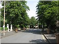
6
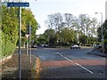
Dumbreck
Junction of Fleurs Avenue and Nithsdale Road.
Image: © Richard Webb
Taken: 25 Sep 2015
0.05 miles
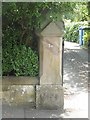
8
Planning notice
A notice of work on a house attached to a rusting lamppost.
Image: © Richard Webb
Taken: 16 Jun 2009
0.07 miles
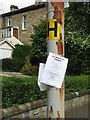
10
Erskine Avenue, Dumbreck
Recycling day.
Image: © Richard Webb
Taken: 16 Jun 2009
0.09 miles