IMAGES TAKEN NEAR TO
Glencairn Drive, GLASGOW, G41 4PS
Introduction
This page details the photographs taken nearby to Glencairn Drive, G41 4PS by members of the Geograph project.
The Geograph project started in 2005 with the aim of publishing, organising and preserving representative images for every square kilometre of Great Britain, Ireland and the Isle of Man.

There are currently over 7.5m images from over14,400 individuals and you can help contribute to the project by visiting https://www.geograph.org.uk
Image Map
Images are licensed for reuse under creativecommons.org/licenses/by-sa/2.0
Notes
- Clicking on the map will re-center to the selected point.
- The higher the marker number, the further away the image location is from the centre of the postcode.
Image Listing (86 Images Found)
Images are licensed for reuse under creativecommons.org/licenses/by-sa/2.0
Image
Details
Distance
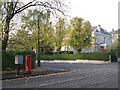
1
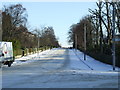
Glencairn Drive
Glencairn Gardens runs to the right.
Image: © Thomas Nugent
Taken: 6 Jan 2010
0.02 miles
2
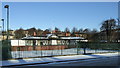
Titwood Bowling Club
The rear of the clubhouse, viewed from Terregles Avenue.
Image: © Thomas Nugent
Taken: 6 Jan 2010
0.02 miles
3
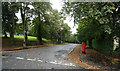
Leslie Road, Pollokshields
Showing position of Postbox No. G41 115.
See Image] for postbox.
Image: © JThomas
Taken: 14 Sep 2021
0.02 miles
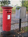
4
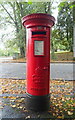
Rare Edward VIII postbox on Leslie Road, Pollokshields
Postbox No. G41 115.
See Image] for context.
Image: © JThomas
Taken: 14 Sep 2021
0.03 miles
5
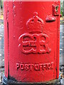
Edward VIII postbox, Leslie Road / Glencairn Drive, G41 - royal cipher
See Image
Image: © Mike Quinn
Taken: 21 Oct 2010
0.03 miles
6
Edward VIII postbox, Leslie Road / Glencairn Drive, G41
Image: © Mike Quinn
Taken: 21 Oct 2010
0.03 miles
7
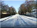
Leslie Road
From Terregles Avenue. Titwoor Park is on the right.
Image: © Thomas Nugent
Taken: 6 Jan 2010
0.03 miles
8
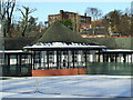
Titwood Lawn Tennis Club
The Category C Listed Arts & Crafts style clubhouse, viewed from Terregles Avenue.
Adjacent to Titwood Bowling Club Image
The following text was extracted from the official Listing and provides some detail about the establishment of the Titwood recreation site. More extensive detail is available from the Listing http://portal.historicenvironment.scot/designation/LB44656. The building shown in this photo is the 'second pavilion' referred to below.
"The history of the Titwood recreational site began on 5 May 1889, when a number of Pollokshields residents met in the house of Mr James Mair Davies in Glencairn Drive to discuss the founding of a new club. The unanimous agreement of those present was that a Bowling and Tennis Club be formed and that sufficient ground be leased in Glencairn Drive from Sir John Stirling-Maxwell for two bowling greens and several tennis courts. The grounds and first pavilion at Titwood were completed by the summer of 1890 and was for both tennis and bowling members. By 1913 a second pavilion, designed by Walker & Ramsay, was constructed and was described at the time as 'tennis pavilion for gentlemen members of Titwood Bowling Club'."
Image: © Thomas Nugent
Taken: 6 Jan 2010
0.03 miles
9
Leslie Road / Glencairn Drive, G41 (2)
Shows the location of Image
Image: © Mike Quinn
Taken: 21 Oct 2010
0.04 miles
10
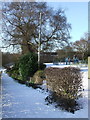
Titwood Park
Looking down the path to Leslie Road and Terregles Avenue.
Image: © Thomas Nugent
Taken: 6 Jan 2010
0.05 miles