IMAGES TAKEN NEAR TO
Hamilton Avenue, GLASGOW, G41 4HB
Introduction
This page details the photographs taken nearby to Hamilton Avenue, G41 4HB by members of the Geograph project.
The Geograph project started in 2005 with the aim of publishing, organising and preserving representative images for every square kilometre of Great Britain, Ireland and the Isle of Man.

There are currently over 7.5m images from over14,400 individuals and you can help contribute to the project by visiting https://www.geograph.org.uk
Image Map
Images are licensed for reuse under creativecommons.org/licenses/by-sa/2.0
Notes
- Clicking on the map will re-center to the selected point.
- The higher the marker number, the further away the image location is from the centre of the postcode.
Image Listing (39 Images Found)
Images are licensed for reuse under creativecommons.org/licenses/by-sa/2.0
Image
Details
Distance

2
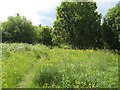
Buttercups, Dumbreck
A strip of woodland and meadow beside the M77.
Image: © Richard Webb
Taken: 16 Jun 2009
0.09 miles
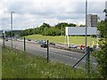
3

The M77 at Dumbreck
Section of Glasgow's newest motorway, constructed between 1994 and 1997. Soon to lose that title to the M74 extension.
Image: © Stephen Sweeney
Taken: 25 Feb 2009
0.10 miles
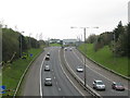
4
M77 approaching junction 1
The scene of a queue most morning. The M77 connects Glasgow with Ayrshire.
The tower block has a good view over Bellahouston Park.
Image: © Richard Webb
Taken: 16 Jun 2009
0.13 miles


8
M77 at Dumbreck
Looking along the southbound carriageway towards Junction 1.
Image: © G Laird
Taken: 14 Apr 2009
0.14 miles
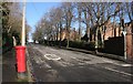
9
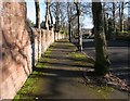
Wall and pavement, Springkell Avenue
The wall is included in the designation of the Category B listed house to which it belongs [http://portal.historicenvironment.scot/designation/LB33471].
Image: © Richard Sutcliffe
Taken: 9 Feb 2018
0.14 miles
10
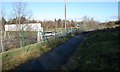
Footpath beside the M77
The footpath follows the edge of The Cunyon, an area of scrubby woodland, which is designated as a Site of Importance for Nature Conservation (SINC) by Glasgow City Council. The Cunyon was once of a much greater extent, but much of it was destroyed when the adjacent M77 motorway was constructed.
Image: © Richard Sutcliffe
Taken: 9 Feb 2018
0.16 miles