IMAGES TAKEN NEAR TO
Hamilton Avenue, GLASGOW, G41 4EX
Introduction
This page details the photographs taken nearby to Hamilton Avenue, G41 4EX by members of the Geograph project.
The Geograph project started in 2005 with the aim of publishing, organising and preserving representative images for every square kilometre of Great Britain, Ireland and the Isle of Man.

There are currently over 7.5m images from over14,400 individuals and you can help contribute to the project by visiting https://www.geograph.org.uk
Image Map
Images are licensed for reuse under creativecommons.org/licenses/by-sa/2.0
Notes
- Clicking on the map will re-center to the selected point.
- The higher the marker number, the further away the image location is from the centre of the postcode.
Image Listing (29 Images Found)
Images are licensed for reuse under creativecommons.org/licenses/by-sa/2.0
Image
Details
Distance
1

Moorland by the M77
Looking towards Dumbreck.
Image: © Stephen Sweeney
Taken: 25 Feb 2009
0.02 miles
2

124 Springkell Avenue
A Category A listed building [http://portal.historicenvironment.scot/designation/LB33486] dating from 1910.
Image: © Richard Sutcliffe
Taken: 9 Feb 2018
0.07 miles
3

Footpath through The Cunyon
An area of scrubby woodland, which is designated as a Site of Importance for Nature Conservation (SINC) by Glasgow City Council. The Cunyon was once of a much greater extent, but much of it was destroyed when the adjacent M77 motorway was constructed.
Image: © Richard Sutcliffe
Taken: 9 Feb 2018
0.09 miles

7
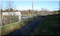
Footpath beside the M77
The footpath follows the edge of The Cunyon, an area of scrubby woodland, which is designated as a Site of Importance for Nature Conservation (SINC) by Glasgow City Council. The Cunyon was once of a much greater extent, but much of it was destroyed when the adjacent M77 motorway was constructed.
Image: © Richard Sutcliffe
Taken: 9 Feb 2018
0.11 miles
8

Cycle track to Glasgow and Dumbreck
At Dumbreck Road.
Image: © Stephen Sweeney
Taken: 25 Feb 2009
0.12 miles
9

Overhead Sign Gantry at M77 Dumbreck Interchange
A typical “Glasgow-type” sign gantry at Junction 1 of the M77 (Dumbreck Interchange).
Gantries of this type were first erected as part of the construction of the Kingston Bridge and its approach roads in 1970 and they are now a familiar sight on the motorway network around Glasgow. They have the following distinctive elements:
• near and offside support legs (basically 2 rectangular hollow sections with base plates to allow connections to the foundations),
• a main frame (made up of rectangular hollow sections) - Over clad on the front and rear,
• a sub frame (made up of smaller hollow sections and welded to main frame),
• a sign face - acrylic sheets hung from the front of the sub frame over its full height,
• internal electrics - sign lighting provided through the use of several dozen fluorescent battens.
More information on “Glasgow Style Gantries” at https://web.archive.org/web/20141106003519/http://www.glasgows-motorways.co.uk/glasgow-gantries/4578281645
(Glasgow’s Motorways, archived November 2014)
Image: © David Dixon
Taken: 24 Sep 2019
0.12 miles