IMAGES TAKEN NEAR TO
Terregles Crescent, GLASGOW, G41 4BT
Introduction
This page details the photographs taken nearby to Terregles Crescent, G41 4BT by members of the Geograph project.
The Geograph project started in 2005 with the aim of publishing, organising and preserving representative images for every square kilometre of Great Britain, Ireland and the Isle of Man.

There are currently over 7.5m images from over14,400 individuals and you can help contribute to the project by visiting https://www.geograph.org.uk
Image Map
Images are licensed for reuse under creativecommons.org/licenses/by-sa/2.0
Notes
- Clicking on the map will re-center to the selected point.
- The higher the marker number, the further away the image location is from the centre of the postcode.
Image Listing (31 Images Found)
Images are licensed for reuse under creativecommons.org/licenses/by-sa/2.0
Image
Details
Distance
1
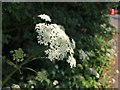
Head of cow parsley beside Dumbreck Road
Image: © Alec MacKinnon
Taken: 13 Jul 2013
0.09 miles
2
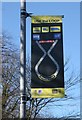
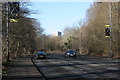
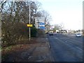
Use the Loop sign, Dumbreck Road
One of several signs recommending motorists to 'Use the Loop' rather than continue along Dumbreck Road.
Motorists wanting to head west on the M8 should first go east on the M77, exit at the next junction and go round the 'Seaward Street Loop', which allows traffic from the M77 to join the M8 heading west. This is intended to reduce traffic on the next section of Dumbreck Road, which is partly residential.
Image: © Richard Sutcliffe
Taken: 9 Feb 2018
0.12 miles
3
Dumbreck Road
Despite similarities, the signs on the lamp posts [http://www.geograph.org.uk/photo/5676299] are not political messages from the Scottish Nationalist Party. In fact they are signs recommending motorists to 'Use the Loop' rather than continue along Dumbreck Road.
Motorists wanting to head west on the M8 should first go east on the M77, exit at the next junction and go round the 'Seaward Street Loop', which allows traffic from the M77 to join the M8 heading west. This is intended to reduce traffic on the next section of Dumbreck Road, which is partly residential.
Image: © Richard Sutcliffe
Taken: 9 Feb 2018
0.12 miles
4
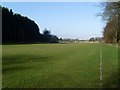
Rugby pitches in Pollok Country Park
On the north side of the park, by Dumbreck Road.
Image: © Stephen Sweeney
Taken: 25 Feb 2009
0.12 miles
5
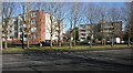
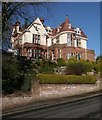
Flats, Haggswood Avenue
Seen from across Dumbreck Road.
Image: © Richard Sutcliffe
Taken: 9 Feb 2018
0.14 miles
6
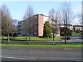
Flats on Terregles Crescent
Right across the road from Pollok Country Park.
Image: © Stephen Sweeney
Taken: 25 Feb 2009
0.14 miles
7
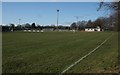
Cartha Queen's Park RFC ground, Dumbreck
Image: © Richard Sutcliffe
Taken: 9 Feb 2018
0.18 miles
8
Road sign on approach to M77
On the B768, Dumbreck Road.
Image: © Stephen Sweeney
Taken: 25 Feb 2009
0.18 miles