IMAGES TAKEN NEAR TO
Moss Side Road, GLASGOW, G41 3TL
Introduction
This page details the photographs taken nearby to Moss Side Road, G41 3TL by members of the Geograph project.
The Geograph project started in 2005 with the aim of publishing, organising and preserving representative images for every square kilometre of Great Britain, Ireland and the Isle of Man.

There are currently over 7.5m images from over14,400 individuals and you can help contribute to the project by visiting https://www.geograph.org.uk
Image Map (Loading...)


Getting Data...Please wait
Leaflet Map data © OpenStreetMap
Images are licensed for reuse under creativecommons.org/licenses/by-sa/2.0
Notes
- Clicking on the map will re-center to the selected point.
- The higher the marker number, the further away the image location is from the centre of the postcode.
Image Listing (48 Images Found)
Images are licensed for reuse under creativecommons.org/licenses/by-sa/2.0
Image
Details
Distance
2
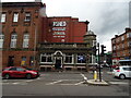
Georgic, Pollokshaws Road
Public bar, named after the MV Georgic - the last ship built for the White Star Line before its merger with the Cunard Line. She was launched in 1931 and served as a troop ship during the second world war. She was eventually withdrawn from service and scrapped in 1956.
Image: © Richard Sutcliffe
Taken: 15 Aug 2019
0.04 miles
3
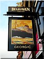
Sign for the Georgic
Public bar on Pollokshaws Road https://www.geograph.org.uk/photo/6243174.
The sign features the MV Georgic - the last ship built for the White Star Line before its merger with the Cunard Line. She was launched in 1931 and served as a troop ship during the second world war. She was eventually withdrawn from service and scrapped in 1956.
Image: © Richard Sutcliffe
Taken: 15 Aug 2019
0.04 miles
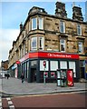
4
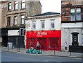
Shelter Scotland
Charity shop at Shawlands Cross.
Image: © Richard Sutcliffe
Taken: 15 Aug 2019
0.04 miles
5
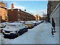
Frankfort Street, Shawlands
During the big freeze of December 2010.
Image: © Stephen Sweeney
Taken: 2 Dec 2010
0.04 miles
6
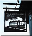
Sign for The Granary
Public bar at Shawlands https://www.geograph.org.uk/photo/6243262.
Image: © Richard Sutcliffe
Taken: 15 Aug 2019
0.04 miles
7
Crossmyloof Mansions and the Granary
A very distinctive tenement build around 1890. The Granary, a traditional public bar is located on the ground floor. It was established in 1962 in the part of the building that had been used by Glasgow Tramways.
Image: © Richard Sutcliffe
Taken: 15 Aug 2019
0.04 miles
8
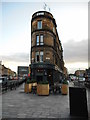
The Butterfly and the Pig
Originally the Corona Bar, designed by architect J.H. Craigie (1870 - 1930) and built by Clarke and Bell in 1912-1913. This distinctive building opened as the Butterfly and the Pig (south) in 2016. There is another bar by the same name in the city centre.
Image: © Richard Sutcliffe
Taken: 15 Aug 2019
0.09 miles
9
The Corona Bar and Kitchen, Shawlands, Glasgow
Image: © JThomas
Taken: 14 Sep 2021
0.09 miles
10
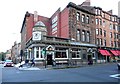
Clydesdale Bank, Shawlands
At the corner of Kilmarnock Road and Mount Stuart Street.
Image: © Richard Sutcliffe
Taken: 15 Aug 2019
0.09 miles