IMAGES TAKEN NEAR TO
Walton Street, GLASGOW, G41 3LR
Introduction
This page details the photographs taken nearby to Walton Street, G41 3LR by members of the Geograph project.
The Geograph project started in 2005 with the aim of publishing, organising and preserving representative images for every square kilometre of Great Britain, Ireland and the Isle of Man.

There are currently over 7.5m images from over14,400 individuals and you can help contribute to the project by visiting https://www.geograph.org.uk
Image Map
Images are licensed for reuse under creativecommons.org/licenses/by-sa/2.0
Notes
- Clicking on the map will re-center to the selected point.
- The higher the marker number, the further away the image location is from the centre of the postcode.
Image Listing (66 Images Found)
Images are licensed for reuse under creativecommons.org/licenses/by-sa/2.0
Image
Details
Distance
1
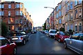
Deanston Drive, Shawlands, Glasgow
This part of Shawlands consists of mainly residential flats. Car parking can be a real problem in this area it not being unusual for residents to have to park some distance from their home.
Image: © Bill Kasman
Taken: 26 Jun 2019
0.02 miles
2

Memorial plaque
On the pavement at the junction of Deanston Drive and Strathyre Street, Shawlands, Glasgow, can be found this memorial plaque to a firefighter who died in the performance of his duties https://www.firescotland.gov.uk/the-firefighters-heritage-trail/deanston-drive.aspx#
Image: © Bill Kasman
Taken: 26 Jun 2019
0.03 miles
3
Deanston Drive
Residential street in Shawlands.
Image: © Richard Sutcliffe
Taken: 8 Sep 2023
0.04 miles
4
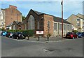
Langside and Shawlands United Free Church of Scotland
On the corner of Millwood Street and Deanston Drive. The church was formally opened in 1934, but appears to have closed recently.
Image: © Richard Sutcliffe
Taken: 8 Sep 2023
0.06 miles
5
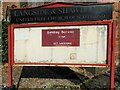
Church noticeboard
The noticeboard for Langside and Shawlands United Free Church of Scotland. The church is now closed.
Image: © Richard Sutcliffe
Taken: 8 Sep 2023
0.06 miles
6
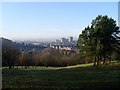
View across Glasgow's Shawlands
From Hill 60 in Queen's Park.
Image: © Stephen Sweeney
Taken: 28 Jan 2009
0.06 miles
7
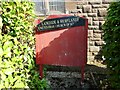
Delapidated church noticeboard
A noticeboard for Langside and Shawlands United Free Church of Scotland. The church is now closed.
Image: © Richard Sutcliffe
Taken: 8 Sep 2023
0.07 miles
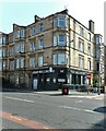
8
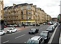
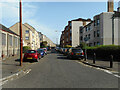
Kilmarnock Road, Shawlands
The ground floor property in the tenement on the corner of Kilmarnock Road (A77) and Walton Street is currently occupied by a Marie Curie charity shop.
Image: © Richard Sutcliffe
Taken: 11 Jul 2019
0.07 miles
9
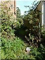
Overgrown lane
The back lane runs behind properties on Kilmarnock Road from Millford Street to Walton Street.
Image: © Richard Sutcliffe
Taken: 8 Sep 2023
0.08 miles
10
The Millwood
A public house on Kilmarnock Road, Shawlands. It was previously Finlay's, but re-opened as The Millwood in August 2023.
Image: © Richard Sutcliffe
Taken: 8 Sep 2023
0.09 miles