IMAGES TAKEN NEAR TO
Holmbank Avenue, GLASGOW, G41 3JQ
Introduction
This page details the photographs taken nearby to Holmbank Avenue, G41 3JQ by members of the Geograph project.
The Geograph project started in 2005 with the aim of publishing, organising and preserving representative images for every square kilometre of Great Britain, Ireland and the Isle of Man.

There are currently over 7.5m images from over14,400 individuals and you can help contribute to the project by visiting https://www.geograph.org.uk
Image Map
Images are licensed for reuse under creativecommons.org/licenses/by-sa/2.0
Notes
- Clicking on the map will re-center to the selected point.
- The higher the marker number, the further away the image location is from the centre of the postcode.
Image Listing (70 Images Found)
Images are licensed for reuse under creativecommons.org/licenses/by-sa/2.0
Image
Details
Distance
1
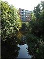
White Cart Water
Looking from the Macquisten Bridge towards a block of flats at 16 Holmbank Avenue.
Image: © Richard Sutcliffe
Taken: 8 Sep 2023
0.03 miles
2
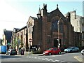
Re:Hope Church, Southside
Church in the former South Shawlands Church of Scotland on the corner of Regwood Street and Deanston Drive. The building dates from 1912-13 and is Category B listed https://portal.historicenvironment.sc.ot/designation/LB33961
Image: © Richard Sutcliffe
Taken: 8 Sep 2023
0.03 miles
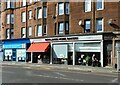
3

Fur 'N' Feathers
Pet shop on Kilmarnock Road.
Image: © Richard Sutcliffe
Taken: 8 Sep 2023
0.04 miles
4
Newlands Home Bakery
Cafe and delicatessen, next door to Allied Surveyors Scotland, on Kilmarnock Road.
Image: © Richard Sutcliffe
Taken: 8 Sep 2023
0.04 miles
5
The Dapper Mongoose
Restaurant on Kilmarnock Road, Shawlands.
Image: © Richard Sutcliffe
Taken: 8 Sep 2023
0.04 miles
6
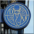
Sign for The Dapper Mongoose
Restaurant on Kilmarnock Road Image
Image: © Richard Sutcliffe
Taken: 8 Sep 2023
0.04 miles
7
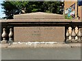
Macquisten Bridge
An inscription on the parapet of the Macquisten Bridge, which carries the A77, Kilmarnock Road over the White Cart Water. The bridge, which is Category C listed https://portal.historicenvironment.scot/designation/LB33925 was built in 1832 and widened in 1907 by James Gibson.
Image: © Richard Sutcliffe
Taken: 8 Sep 2023
0.04 miles
8
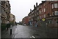
Kilmarnock Road, Shawlands
A wet morning in Shawlands. Looking south along the A77.
Image: © Richard Sutcliffe
Taken: 24 Oct 2015
0.04 miles
9
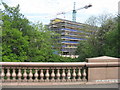
New building at Langside
Seen from the A77 bridge over the White Cart Water, with very fine polished granite balusters.
Image: © M J Richardson
Taken: 31 May 2014
0.05 miles
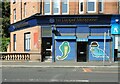
10

Shops at Shawlands
Clyde Property and Docherty Chemist on Kilmarnock Road.
Image: © Richard Sutcliffe
Taken: 8 Sep 2023
0.05 miles