1
New building at Langside
Seen from the A77 bridge over the White Cart Water, with very fine polished granite balusters.
Image: © M J Richardson
Taken: 31 May 2014
0.03 miles
2
White Cart Water
Looking from the Macquisten Bridge towards a block of flats at 16 Holmbank Avenue.
Image: © Richard Sutcliffe
Taken: 8 Sep 2023
0.05 miles
3
Shops on Kilmarnock Road
Barnardo's (charity shop), The Thai (bar and restaurant) and Papa Johns (pizzas).
Image: © Richard Sutcliffe
Taken: 8 Sep 2023
0.08 miles
4
Re:Hope Church, Southside
Church in the former South Shawlands Church of Scotland on the corner of Regwood Street and Deanston Drive. The building dates from 1912-13 and is Category B listed https://portal.historicenvironment.sc.ot/designation/LB33961
Image: © Richard Sutcliffe
Taken: 8 Sep 2023
0.09 miles
5
Kilmarnock Road, Shawlands
A wet morning in Shawlands. Looking south along the A77.
Image: © Richard Sutcliffe
Taken: 24 Oct 2015
0.09 miles
6
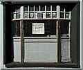
Closing Down
A notice in the window says: 'Closing down on Friday 30th June'.
This small shop was for many years Wm. Lang Shoe Repairs. It also did key cutting. It closed down in 2023.
Image: © Richard Sutcliffe
Taken: 8 Sep 2023
0.09 miles
7
Closed shop
This small shop was for many years Wm. Lang Shoe Repairs. It also did key cutting. It closed down (according to the sign in the window) on Friday 30th June (2023).
Image: © Richard Sutcliffe
Taken: 8 Sep 2023
0.09 miles
8
Macquisten Bridge
An inscription on the parapet of the Macquisten Bridge, which carries the A77, Kilmarnock Road over the White Cart Water. The bridge, which is Category C listed https://portal.historicenvironment.scot/designation/LB33925 was built in 1832 and widened in 1907 by James Gibson.
Image: © Richard Sutcliffe
Taken: 8 Sep 2023
0.09 miles
9
Tenement block, Kilmarnock Road
Tenements with shops and flats above.
Image: © Richard Sutcliffe
Taken: 8 Sep 2023
0.09 miles
10
Railway bridge over Kilmarock Road
The bridge is at the southeast end of Pollokshaws East station. It is actually two almost parallel bridges each carrying one track. They date from 1894 and carry the Cathcart Circle railway lines over the A77, Kilmarnock Road.
Image: © Richard Sutcliffe
Taken: 8 Sep 2023
0.09 miles


