IMAGES TAKEN NEAR TO
Woodford Street, GLASGOW, G41 3HP
Introduction
This page details the photographs taken nearby to Woodford Street, G41 3HP by members of the Geograph project.
The Geograph project started in 2005 with the aim of publishing, organising and preserving representative images for every square kilometre of Great Britain, Ireland and the Isle of Man.

There are currently over 7.5m images from over14,400 individuals and you can help contribute to the project by visiting https://www.geograph.org.uk
Image Map
Images are licensed for reuse under creativecommons.org/licenses/by-sa/2.0
Notes
- Clicking on the map will re-center to the selected point.
- The higher the marker number, the further away the image location is from the centre of the postcode.
Image Listing (53 Images Found)
Images are licensed for reuse under creativecommons.org/licenses/by-sa/2.0
Image
Details
Distance
1
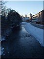
White Cart at Millbrae Road
The picture looks west along the White Cart from the bridge where Millbrae Road turns into Langside Drive. The winter afternoon's dying light reveals some of the topography of the immediate surroundings. The newly completed flood defences can be seen along the right-hand side.
Image: © Alec MacKinnon
Taken: 27 Nov 2010
0.13 miles
2
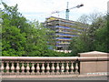
New building at Langside
Seen from the A77 bridge over the White Cart Water, with very fine polished granite balusters.
Image: © M J Richardson
Taken: 31 May 2014
0.13 miles
3
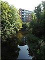
White Cart Water
Looking from the Macquisten Bridge towards a block of flats at 16 Holmbank Avenue.
Image: © Richard Sutcliffe
Taken: 8 Sep 2023
0.15 miles
4
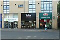
Shops on Kilmarnock Road
Barnardo's (charity shop), The Thai (bar and restaurant) and Papa Johns (pizzas).
Image: © Richard Sutcliffe
Taken: 8 Sep 2023
0.17 miles
5
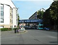
Railway bridge over Kilmarock Road
The bridge is at the southeast end of Pollokshaws East station. It is actually two almost parallel bridges each carrying one track. They date from 1894 and carry the Cathcart Circle railway lines over the A77, Kilmarnock Road.
Image: © Richard Sutcliffe
Taken: 8 Sep 2023
0.17 miles
6
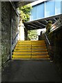
Steps to the station
The steps lead up from the pavement on Kilmarnock Road. Passengers then turn left to go up a ramp and more steps (between the two railway lines) to the island platform of the station.
Image: © Richard Sutcliffe
Taken: 8 Sep 2023
0.18 miles
7
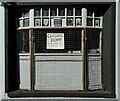
Closing Down
A notice in the window says: 'Closing down on Friday 30th June'.
This small shop was for many years Wm. Lang Shoe Repairs. It also did key cutting. It closed down in 2023.
Image: © Richard Sutcliffe
Taken: 8 Sep 2023
0.18 miles
8
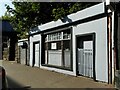
Closed shop
This small shop was for many years Wm. Lang Shoe Repairs. It also did key cutting. It closed down (according to the sign in the window) on Friday 30th June (2023).
Image: © Richard Sutcliffe
Taken: 8 Sep 2023
0.18 miles
9
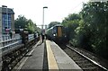
Train arriving at Pollokshaws East station
British Rail Class 380 No 380016 arriving at Pollokshaws East station.
Image: © Richard Sutcliffe
Taken: 8 Sep 2023
0.18 miles
10
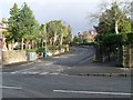
St Bride's Road
In Newlands, Glasgow.
Image: © Stephen Sweeney
Taken: 25 Feb 2009
0.19 miles