IMAGES TAKEN NEAR TO
Herriet Street, GLASGOW, G41 2RH
Introduction
This page details the photographs taken nearby to Herriet Street, G41 2RH by members of the Geograph project.
The Geograph project started in 2005 with the aim of publishing, organising and preserving representative images for every square kilometre of Great Britain, Ireland and the Isle of Man.

There are currently over 7.5m images from over14,400 individuals and you can help contribute to the project by visiting https://www.geograph.org.uk
Image Map
Images are licensed for reuse under creativecommons.org/licenses/by-sa/2.0
Notes
- Clicking on the map will re-center to the selected point.
- The higher the marker number, the further away the image location is from the centre of the postcode.
Image Listing (124 Images Found)
Images are licensed for reuse under creativecommons.org/licenses/by-sa/2.0
Image
Details
Distance
1
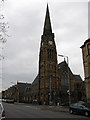
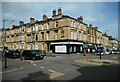
Pollokshields Church
Situated at the corner of Shields Road and Albert Drive. http://www.pollokshieldschurch.org.uk/
Image: © G Laird
Taken: 14 Apr 2009
0.02 miles
3
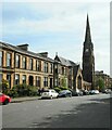
Tenements and Pollokshields Church
The Category B listed http://portal.historicenvironment.scot/designation/LB33477 church was built in 1878.
Image: © Richard Sutcliffe
Taken: 14 May 2022
0.03 miles
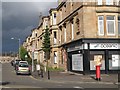
4
Albert Drive / Herriet Street, G41
Shows the location of Image
Image: © Mike Quinn
Taken: 21 Oct 2010
0.03 miles
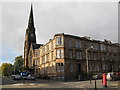
5
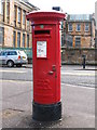
Roundabout, Albert Drive
At the junction with Herriet Street. The tenement on the corner has a carved panel reading 'KEW TERRACE'. The pillar box is an Edward VIII example and is Category B listed http://portal.historicenvironment.scot/designation/LB50819.
Image: © Richard Sutcliffe
Taken: 14 May 2022
0.04 miles
6
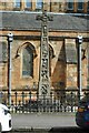
War memorial, Pollokshields
Within the grounds of Pollokshields Church. Dating from 1921, the granite memorial is based on the 8th century sculptured crosses at Bewcastle, Cumbria and Ruthwell, Dumfriesshire. It is Category B listed http://portal.historicenvironment.scot/designation/LB33478.
Image: © Richard Sutcliffe
Taken: 14 May 2022
0.04 miles
7
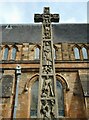
War memorial, Pollokshields
Within the grounds of Pollokshields Church. Dating from 1921, the granite memorial is based on the 8th century sculptured crosses at Bewcastle, Cumbria and Ruthwell, Dumfriesshire. It is Category B listed http://portal.historicenvironment.scot/designation/LB33478.
Image: © Richard Sutcliffe
Taken: 14 May 2022
0.04 miles
8
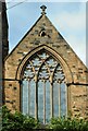
Stained glass window
Impressive tracery in the stained glass window in Pollokshields Church, which is Category B listed http://portal.historicenvironment.scot/designation/LB33477. I'm sure it looks even better from inside.
Image: © Richard Sutcliffe
Taken: 14 May 2022
0.04 miles
9
Edward VIII postbox, Albert Drive / Herriet Street, G41
Image: © Mike Quinn
Taken: 21 Oct 2010
0.04 miles
10
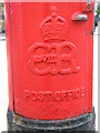
Edward VIII postbox, Albert Drive / Herriet Street, G41 - royal cipher
See Image
Image: © Mike Quinn
Taken: 21 Oct 2010
0.04 miles