IMAGES TAKEN NEAR TO
Pollokshaws Road, GLASGOW, G41 2QB
Introduction
This page details the photographs taken nearby to Pollokshaws Road, G41 2QB by members of the Geograph project.
The Geograph project started in 2005 with the aim of publishing, organising and preserving representative images for every square kilometre of Great Britain, Ireland and the Isle of Man.

There are currently over 7.5m images from over14,400 individuals and you can help contribute to the project by visiting https://www.geograph.org.uk
Image Map
Images are licensed for reuse under creativecommons.org/licenses/by-sa/2.0
Notes
- Clicking on the map will re-center to the selected point.
- The higher the marker number, the further away the image location is from the centre of the postcode.
Image Listing (246 Images Found)
Images are licensed for reuse under creativecommons.org/licenses/by-sa/2.0
Image
Details
Distance
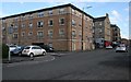
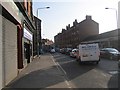
1
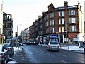
Pollokshaws Road at Nithsdale Street
Looking along Nithsdale Street, Across Pollokshaws Road.
Image: © Thomas Nugent
Taken: 6 Jan 2010
0.02 miles
2
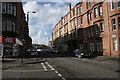
Allison Street
Seen from the junction with Niddrie Road.
Image: © Richard Sutcliffe
Taken: 5 Mar 2017
0.03 miles
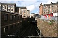
3
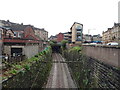
Railway towards Queen's Park Station
Looking south from the bridge on Nithsdale Drive (B763).
Image: © JThomas
Taken: 14 Sep 2021
0.03 miles
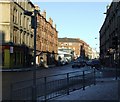
4
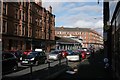
Pollokshaws Road
From the junction with Allison Street. The low grey building is a car showroom.
Image: © Richard Sutcliffe
Taken: 5 Mar 2017
0.03 miles
5
Junction of Nithsdale Street and March Street
Approaching the traffic lights at Pollokshaws Road.
Image: © Richard Sutcliffe
Taken: 5 Mar 2017
0.03 miles
6
Pollokshaws Road
At the junction with Nithsdale Road.
Image: © Thomas Nugent
Taken: 6 Jan 2010
0.04 miles
7
Pollokshaws Road
The road crosses the railway line at Queens Parks Station at this point, but there is no access to the station from here.
Image: © Thomas Nugent
Taken: 6 Jan 2010
0.04 miles
8
Railway bridge under Pollokshaws Road
Seen from Niddrie Road.
Image: © Richard Sutcliffe
Taken: 5 Mar 2017
0.04 miles
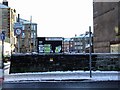
9
Pollokshaws Road
The A77 running south from Glasgow city centre.
Image: © Richard Webb
Taken: 9 Apr 2013
0.04 miles
10
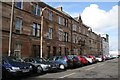
March Street
The more ornate sandstone building near the centre of the street is the former Strathbungo Police Station. Strathbungo was a separate village, but became part of Glasgow in 1891 and the police station closed in 1893.
Image: © Richard Sutcliffe
Taken: 5 Mar 2017
0.04 miles