IMAGES TAKEN NEAR TO
Queen Square, GLASGOW, G41 2BD
Introduction
This page details the photographs taken nearby to Queen Square, G41 2BD by members of the Geograph project.
The Geograph project started in 2005 with the aim of publishing, organising and preserving representative images for every square kilometre of Great Britain, Ireland and the Isle of Man.

There are currently over 7.5m images from over14,400 individuals and you can help contribute to the project by visiting https://www.geograph.org.uk
Image Map (Loading...)


Getting Data...Please wait
Leaflet Map data © OpenStreetMap
Images are licensed for reuse under creativecommons.org/licenses/by-sa/2.0
Notes
- Clicking on the map will re-center to the selected point.
- The higher the marker number, the further away the image location is from the centre of the postcode.
Image Listing (153 Images Found)
Images are licensed for reuse under creativecommons.org/licenses/by-sa/2.0
Image
Details
Distance
1
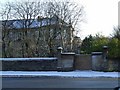
Bricked up entrance
On Darnley Road, near Darnley Place. Possibly a former footbridge over the railway line.
Image: © Thomas Nugent
Taken: 6 Jan 2010
0.07 miles
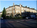
2
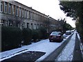
Moray Place
Neat terraced housing on Moray Place. Category A Listed http://portal.historicenvironment.scot/designation/LB32386 by Alexander 'Greek' Thomson, who lived at No. 1.
Image: © Thomas Nugent
Taken: 6 Jan 2010
0.08 miles
3
Pollokshields West railway station
The entrance on Fotheringay Road.
Image: © Thomas Nugent
Taken: 6 Jan 2010
0.09 miles
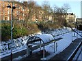
4
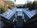
Pollokshields West railway station
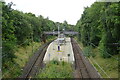
View east from the footbridge to the island platform.
Image: © Thomas Nugent
Taken: 6 Jan 2010
0.09 miles
5
Pollokshaws Road tenements
Across from the entrance to Queen's Park.
Image: © Stephen Sweeney
Taken: 28 Jan 2009
0.10 miles
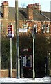
6
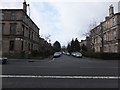
Marywood Square
At its junction with Pollokshaws Road, to the northwest of Queen's Park.
Image: © Barbara Carr
Taken: 22 Apr 2013
0.10 miles
7
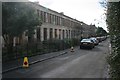
Moray Place
Category A listed two storey tenements designed by Alexander Thomson and built 1859-60.
Image: © Richard Sutcliffe
Taken: 5 Mar 2017
0.10 miles
8
Pollokshields West railway station
Looking across the island platform to Terregles Avenue.
Image: © Thomas Nugent
Taken: 6 Jan 2010
0.11 miles
9
Pollokshields West Station
On the Cathcart Circle Line.
Image: © JThomas
Taken: 14 Sep 2021
0.11 miles
10

Pollokshields West railway station, Glasgow
Opened in 1894 by the Cathcart District Railway and today is part of the Cathcart Circle.
View east, the line then curves round towards Glasgow.
Image: © Nigel Thompson
Taken: 19 Feb 2014
0.11 miles