IMAGES TAKEN NEAR TO
Pollokshaws Road, GLASGOW, G41 2AD
Introduction
This page details the photographs taken nearby to Pollokshaws Road, G41 2AD by members of the Geograph project.
The Geograph project started in 2005 with the aim of publishing, organising and preserving representative images for every square kilometre of Great Britain, Ireland and the Isle of Man.

There are currently over 7.5m images from over14,400 individuals and you can help contribute to the project by visiting https://www.geograph.org.uk
Image Map
Images are licensed for reuse under creativecommons.org/licenses/by-sa/2.0
Notes
- Clicking on the map will re-center to the selected point.
- The higher the marker number, the further away the image location is from the centre of the postcode.
Image Listing (230 Images Found)
Images are licensed for reuse under creativecommons.org/licenses/by-sa/2.0
Image
Details
Distance
1
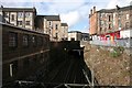
Railway bridge under Pollokshaws Road
Seen from Niddrie Road.
Image: © Richard Sutcliffe
Taken: 5 Mar 2017
0.02 miles
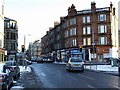
2
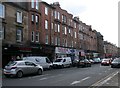
Pollokshaws Road
Businesses include 'Rum Shack' (Caribbean Bar & Canteen), 'Panda House' (Peking Cantones Cuisine) and 'Right Way Legal'.
Image: © Richard Sutcliffe
Taken: 5 Mar 2017
0.02 miles
3
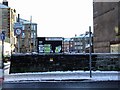
Pollokshaws Road
The road crosses the railway line at Queens Parks Station at this point, but there is no access to the station from here.
Image: © Thomas Nugent
Taken: 6 Jan 2010
0.02 miles
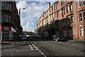
4
Junction of Nithsdale Street and March Street
Approaching the traffic lights at Pollokshaws Road.
Image: © Richard Sutcliffe
Taken: 5 Mar 2017
0.03 miles
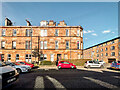
5
Pollokshaws Road at Nithsdale Street
Looking along Nithsdale Street, Across Pollokshaws Road.
Image: © Thomas Nugent
Taken: 6 Jan 2010
0.03 miles
6

Pollokshaws Road
From the junction with Allison Street.
Image: © Richard Sutcliffe
Taken: 5 Mar 2017
0.03 miles
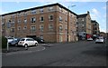
7
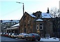
Nithsdale Street
The old building in the foreground has some bricks missing and appears to be disused.
Image: © Thomas Nugent
Taken: 6 Jan 2010
0.04 miles
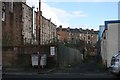
9
Allison Street
Seen from the junction with Niddrie Road.
Image: © Richard Sutcliffe
Taken: 5 Mar 2017
0.04 miles
10
Lane off Torrisdale Street
Running between properties on Pollokshaws Road and Niddrie Road.
Image: © Richard Sutcliffe
Taken: 5 Mar 2017
0.05 miles