IMAGES TAKEN NEAR TO
Barrland Court, GLASGOW, G41 1RN
Introduction
This page details the photographs taken nearby to Barrland Court, G41 1RN by members of the Geograph project.
The Geograph project started in 2005 with the aim of publishing, organising and preserving representative images for every square kilometre of Great Britain, Ireland and the Isle of Man.

There are currently over 7.5m images from over14,400 individuals and you can help contribute to the project by visiting https://www.geograph.org.uk
Image Map
Images are licensed for reuse under creativecommons.org/licenses/by-sa/2.0
Notes
- Clicking on the map will re-center to the selected point.
- The higher the marker number, the further away the image location is from the centre of the postcode.
Image Listing (139 Images Found)
Images are licensed for reuse under creativecommons.org/licenses/by-sa/2.0
Image
Details
Distance
1
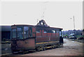
Glasgow permanent way tram
Glasgow permanent way tram seen at Barrland Street yard just before the end of the Glasgow trams in September 1962. This is a cut down version of a former double deck tramcar.
Image: © Chris Coleman
Taken: Unknown
0.01 miles
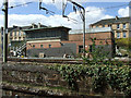
2
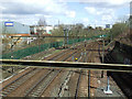
Tracks north of Pollokshields East railway station
Some of the many lines which criss-cross this part of the city. Viewed from the Albert Drive bridge.
Image: © Thomas Nugent
Taken: 27 Apr 2013
0.06 miles
3
Tracks north of Pollokshields East railway station
Some of the many lines which criss-cross this part of the city. Viewed from the Albert Drive bridge.
Image: © Thomas Nugent
Taken: 27 Apr 2013
0.07 miles
4
Pollokshields East Junction
Just north of Pollokshields East Station.
Image: © Richard Sutcliffe
Taken: 14 May 2022
0.07 miles
5
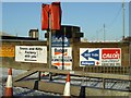
Signs
An unusual mix of signs on Kilbirnie Street.
Image: © Thomas Nugent
Taken: 6 Jan 2010
0.07 miles
6
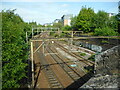
Old signal box at Pollokshields East station
The box is on a different line from the station itself.
Image: © Thomas Nugent
Taken: 27 Apr 2013
0.08 miles
7
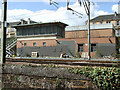
Old signal box at Pollokshields East station
The box is on a different line from the station itself.
Image: © Thomas Nugent
Taken: 27 Apr 2013
0.08 miles
8
South Gate
A new housing development on Pollokshaws Road at Muirhouse Street.
Image: © Thomas Nugent
Taken: 6 Jan 2010
0.08 miles
9
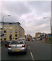
Pollokshaws Road at the Albert Drive traffic lights
Image: © Elliott Simpson
Taken: 28 Apr 2014
0.08 miles
10
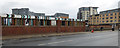
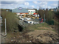
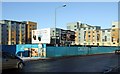
Brownfield site on Albert Drive
The site of a former building materials depot.
Image: © Thomas Nugent
Taken: 15 Oct 2016
0.08 miles