IMAGES TAKEN NEAR TO
Pollokshaws Road, GLASGOW, G41 1PX
Introduction
This page details the photographs taken nearby to Pollokshaws Road, G41 1PX by members of the Geograph project.
The Geograph project started in 2005 with the aim of publishing, organising and preserving representative images for every square kilometre of Great Britain, Ireland and the Isle of Man.

There are currently over 7.5m images from over14,400 individuals and you can help contribute to the project by visiting https://www.geograph.org.uk
Image Map
Images are licensed for reuse under creativecommons.org/licenses/by-sa/2.0
Notes
- Clicking on the map will re-center to the selected point.
- The higher the marker number, the further away the image location is from the centre of the postcode.
Image Listing (291 Images Found)
Images are licensed for reuse under creativecommons.org/licenses/by-sa/2.0
Image
Details
Distance
1
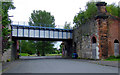
Salisbury Street
Passes under the City Union railway line between Cavendish Place and Cumberland Street at the site of the former Cumberland Street station.
Image: © Thomas Nugent
Taken: 31 Jul 2011
0.02 miles
2
Salisbury Street
The former Cumberland Street railway station. The line is still in use for freight and occasional train movements only.
Image: © Thomas Nugent
Taken: 31 Jul 2011
0.02 miles
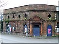
3
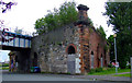
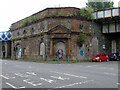
Cumberland Street railway station (site), Glasgow
Opened in 1900 as "Eglinton Street" by the Glasgow & South Western Railway on the lines south west from Glasgow St. Enoch's, this station replaced the one at Main Street which closed at the same time. It was renamed "Cumberland Street" in 1924 and closed in 1966.
View south east at one of the former entrances, which was bricked up in 2012.
Image: © Nigel Thompson
Taken: 29 Apr 2019
0.03 miles
4
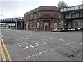
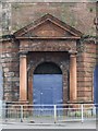
Former Cumberland Street railway station
On the now freight only City Union line which runs through The Gorbals. Opened in 1900 by the Glasgow & South Western Railway as Eglinton Street, renamed to Cumberland Street in 1920. The station closed in 1966.
Category B Listed https://portal.historicenvironment.scot/designation/LB49934 .
Image: © Thomas Nugent
Taken: 24 Sep 2023
0.04 miles
5
Former Cumberland Street railway station
On the now freight only City Union line which runs through The Gorbals. Opened in 1900 by the Glasgow & South Western Railway as Eglinton Street, renamed to Cumberland Street in 1920. The station closed in 1966.
Category B Listed https://portal.historicenvironment.scot/designation/LB49934 .
Image: © Thomas Nugent
Taken: 24 Sep 2023
0.04 miles
6
Cumberland Street Station
Image: © Thomas Nugent
Taken: 13 Feb 2009
0.04 miles
7

Mural at the former Cumberland Street railway bridge
Artist and subject unknown.
Image: © Thomas Nugent
Taken: 24 Sep 2023
0.04 miles
8
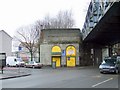
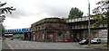
Railway bridge in The Gorbals
Carries the former City Union Railway line over Cumberland Street. The edge of the disused Cumberland Street station can be seen to the right Image
Image: © Thomas Nugent
Taken: 13 Feb 2009
0.04 miles
9
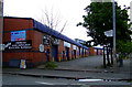
Cumberland Street
Industrial units, backing onto the City Union railway line.
Image: © Thomas Nugent
Taken: 31 Jul 2011
0.04 miles
10
Cumberland Street Station
A disused station on the former City Union Railway line in The Gorbals. The line is still open.
Image: © Thomas Nugent
Taken: 13 Feb 2009
0.05 miles