IMAGES TAKEN NEAR TO
Admiral Path, GLASGOW, G41 1HW
Introduction
This page details the photographs taken nearby to Admiral Path, G41 1HW by members of the Geograph project.
The Geograph project started in 2005 with the aim of publishing, organising and preserving representative images for every square kilometre of Great Britain, Ireland and the Isle of Man.

There are currently over 7.5m images from over14,400 individuals and you can help contribute to the project by visiting https://www.geograph.org.uk
Image Map (Loading...)


Getting Data...Please wait
Leaflet Map data © OpenStreetMap
Images are licensed for reuse under creativecommons.org/licenses/by-sa/2.0
Notes
- Clicking on the map will re-center to the selected point.
- The higher the marker number, the further away the image location is from the centre of the postcode.
Image Listing (116 Images Found)
Images are licensed for reuse under creativecommons.org/licenses/by-sa/2.0
Image
Details
Distance
1
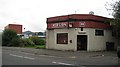
Red Lion
This howff is the only survivor of the block on Paisley Road West. Surrounding land is partly developed with steel and glass car showrooms etc.
Image: © Richard Webb
Taken: 24 Sep 2008
0.03 miles
2
The Old Toll Bar
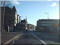
On Paisley Road West at Paisley Road Toll.
Image: © Thomas Nugent
Taken: 18 Jul 2011
0.04 miles
3
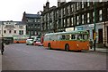
Glasgow single-deck trolleybus, Paisley Road Toll, 1966
These were the last single-deck trolleybuses to be built in the UK, and the last to remain in service. They were used exclusively on the suburban route 108 between Paisley Road Toll and Mount Florida which negotiated a low bridge. When built, special dispensation had to be obtained as they exceed the maximum permitted length for a bus at that time. In the background a double-deck trolleybus can be seen heading towards the City on route 106.
Also visible is the Imperial Bingo, formerly the Imperial Palace cinema, today still an entertainment venue as Glasgow's Gran Ole Opry country and western club.
Image: © Alan Murray-Rust
Taken: 24 Mar 1966
0.04 miles
4
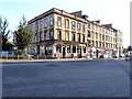
The Old Toll Bar
Public house on Paisley Road West, at its junction with Govan Road.
Image: © David Dixon
Taken: 17 Aug 2010
0.04 miles
5
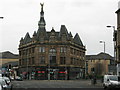
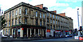
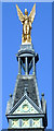
The Angel Building
Named after its crowning glory, the Gilded Angel, the building stands at the fork where Paisley Road (A8) in the foreground splits into Paisley Road West (A8) to the left and Govan Road to the right.
The ground floor, once a gents outfitters, Ogg Bros, is now an Italian restaurant, La Fiorentina.
The Angel itself, Category B listed, of which very little is known of its origin, was extensively restored in the 1990s.
Image: © G Laird
Taken: 10 Jan 2009
0.05 miles
7
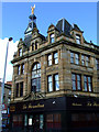
La Fiorentina restaurant
An Italian restaurant http://www.la-fiorentina.com/ at Paisley Road Toll.
Image: © Thomas Nugent
Taken: 18 Jul 2011
0.05 miles
8
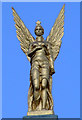
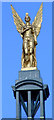
The Govan Angel
This stunning figure has been looking along Paisley Road at Paisley Road Toll since 1890. Best seen in its gilded glory in the morning sun. See also Image & Image
Image: © Thomas Nugent
Taken: 18 Jul 2011
0.05 miles
9
The Govan Angel
This stunning figure has been looking along Paisley Road at Paisley Road Toll since 1890. Best seen in its gilded glory in the morning sun. See also Image & Image
Image: © Thomas Nugent
Taken: 18 Jul 2011
0.05 miles
10
The Govan Angel
This stunning figure has been looking along Paisley Road at Paisley Road Toll since 1890. Best seen in its gilded glory in the morning sun. See also Image & Image
Image: © Thomas Nugent
Taken: 18 Jul 2011
0.05 miles