IMAGES TAKEN NEAR TO
Drygate, GLASGOW, G4 0YD
Introduction
This page details the photographs taken nearby to Drygate, G4 0YD by members of the Geograph project.
The Geograph project started in 2005 with the aim of publishing, organising and preserving representative images for every square kilometre of Great Britain, Ireland and the Isle of Man.

There are currently over 7.5m images from over14,400 individuals and you can help contribute to the project by visiting https://www.geograph.org.uk
Image Map (Loading...)


Getting Data...Please wait
Leaflet Map data © OpenStreetMap
Images are licensed for reuse under creativecommons.org/licenses/by-sa/2.0
Notes
- Clicking on the map will re-center to the selected point.
- The higher the marker number, the further away the image location is from the centre of the postcode.
Image Listing (739 Images Found)
Images are licensed for reuse under creativecommons.org/licenses/by-sa/2.0
Image
Details
Distance
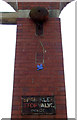
1
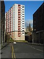
Gibson Heights, 24 Drygate
One of three high-rise blocks of flats on Drygate. Seen from Havannah Street. Glasgow Cathedral can be seen in the far distance.
Image: © Richard Sutcliffe
Taken: 2 Feb 2018
0.02 miles
2
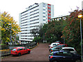
Drygate
One of the three Drygate towerblocks, viewed from Cathedral Square.
Image: © Thomas Nugent
Taken: 5 Nov 2013
0.02 miles
3
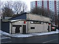
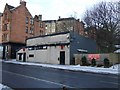
The Lampost Bar
At the west end of Duke Street.
Image: © Thomas Nugent
Taken: 10 Jan 2010
0.02 miles
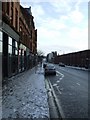
4
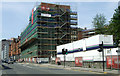
Duke Street
New flats under construction at the High Street end of Duke Street.
Image: © Thomas Nugent
Taken: 14 Jul 2013
0.03 miles
5
The Lampost Bar
At the west end of Duke Street. Note the old BSB satellite "squariel".
Image: © Thomas Nugent
Taken: 10 Jan 2010
0.03 miles
6
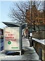
Bus shelter advert
I have no idea what is being advertised on this bus shelter on the north side of Duke Street, but I fully agree with the statement.
Image: © Thomas Nugent
Taken: 10 Jan 2010
0.03 miles
7
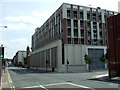
Collegelands
Collegelands is an urban regeneration site on the site of the former College Goods railway station at the corner of High Street and Duke Street. This was the original site of Glasgow University which was located here from 1460 until it moved to the West End in 1870, hence the "college" connection.
Looking east along Duke Street at Havanah Street.
Image: © Thomas Nugent
Taken: 14 Jul 2013
0.03 miles
8
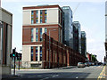
Collegelands
An urban regeneration project at the High Street end of Duke Street on the site of the former College Goods railway station.
Image: © Thomas Nugent
Taken: 14 Jul 2013
0.04 miles
9
Sprinkler Stop Valve Inside
Now part of Collegelands which is an urban regeneration site on the site of the former College Goods railway station at the corner of High Street and Duke Street. This was the original site of Glasgow University which was located here from 1460 until it moved to the West End in 1870, hence the "college" connection.
Looking east along Duke Street from High Street.
Image: © Thomas Nugent
Taken: 14 Jul 2013
0.04 miles
10
Duke Street
Looking east from High Street. The wall on the right was once part of the shed at College Goods station.
Image: © Thomas Nugent
Taken: 10 Jan 2010
0.04 miles