IMAGES TAKEN NEAR TO
Kennedy Path, GLASGOW, G4 0PP
Introduction
This page details the photographs taken nearby to Kennedy Path, G4 0PP by members of the Geograph project.
The Geograph project started in 2005 with the aim of publishing, organising and preserving representative images for every square kilometre of Great Britain, Ireland and the Isle of Man.

There are currently over 7.5m images from over14,400 individuals and you can help contribute to the project by visiting https://www.geograph.org.uk
Image Map (Loading...)


Getting Data...Please wait
Leaflet Map data © OpenStreetMap
Images are licensed for reuse under creativecommons.org/licenses/by-sa/2.0
Notes
- Clicking on the map will re-center to the selected point.
- The higher the marker number, the further away the image location is from the centre of the postcode.
Image Listing (196 Images Found)
Images are licensed for reuse under creativecommons.org/licenses/by-sa/2.0
Image
Details
Distance
1
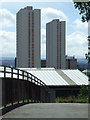
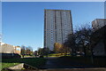
Townhead towerblocks
Viewed across the M8 motorway footbridge from Sighthill Park.
Image: © Thomas Nugent
Taken: 4 Aug 2013
0.04 miles
2
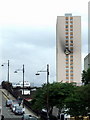
The Towering Inferno
A burned out flat in this tower block in Townhead. Viewed from Montrose Street.
Image: © Thomas Nugent
Taken: 21 Aug 2008
0.06 miles
4
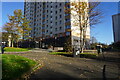
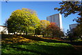
Turf zone CRMGrewUpHere
Dobbie's Loan Place, Townhead, Glasgow.
Image: © Ian S
Taken: 12 Nov 2023
0.08 miles
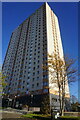
6
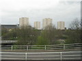
Townhead multistorey flats
Seen looking west from the M8 at J15.
Image: © M J Richardson
Taken: 4 May 2016
0.10 miles
9
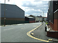
North Wallace Street
Off Baird Street.
Image: © Thomas Nugent
Taken: 5 Jun 2012
0.11 miles
10
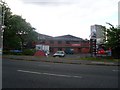
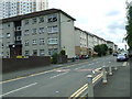
Tiso, Glasgow
Outdoor shop in the city's Townhead.
Image: © Stephen Sweeney
Taken: 19 Jun 2008
0.11 miles