IMAGES TAKEN NEAR TO
Auckland Wynd, GLASGOW, G40 4QY
Introduction
This page details the photographs taken nearby to Auckland Wynd, G40 4QY by members of the Geograph project.
The Geograph project started in 2005 with the aim of publishing, organising and preserving representative images for every square kilometre of Great Britain, Ireland and the Isle of Man.

There are currently over 7.5m images from over14,400 individuals and you can help contribute to the project by visiting https://www.geograph.org.uk
Image Map
Images are licensed for reuse under creativecommons.org/licenses/by-sa/2.0
Notes
- Clicking on the map will re-center to the selected point.
- The higher the marker number, the further away the image location is from the centre of the postcode.
Image Listing (52 Images Found)
Images are licensed for reuse under creativecommons.org/licenses/by-sa/2.0
Image
Details
Distance
1
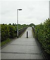
The Cuningar Footbridge
The bridge spans the River Clyde and leads to the Cuningar Loop (so named because of a prominent loop in the river) on the other side.
Image: © Richard Sutcliffe
Taken: 28 Jun 2023
0.01 miles
2
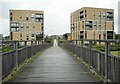
The Cuningar Footbridge
After crossing the River Clyde, the path passes the two apartment blocks and continues to Sunnybank Street.
Image: © Richard Sutcliffe
Taken: 28 Jun 2023
0.01 miles
3
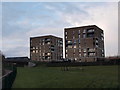
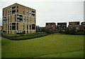
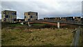
Buildings in the Dalmarnock Athletes' Village
These two buildings were constructed as part of the athletes' village in the 2014 Commonwealth Games. At left the Clyde Walkway heads towards Glasgow city centre.
Image: © Alec MacKinnon
Taken: 30 Mar 2018
0.02 miles
4
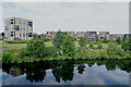
View from the River Clyde bridge
A peaceful river Clyde and reflections of the trees, shrubs and flats on the side of the river.
Image: © Malcolm Neal
Taken: 1 Jul 2021
0.03 miles
5
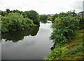
River Clyde
Looking downstream from the Cuningar Footbridge.
Image: © Richard Sutcliffe
Taken: 28 Jun 2023
0.03 miles
6
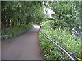
Clyde Walkway, Dalmarnock
Well wooded section of the riverside. Here the path passes through a former industrial area. Aerial photographs allow a glimpse of what is beyond the trees, a large area of woodland, weeds and the floor plans of demolished factories.
The pathway (also National Cycle Route 75) is landscaped here, the river somewhat remote beyond the vegetation.
Image: © Richard Webb
Taken: 25 Jul 2008
0.04 miles
7
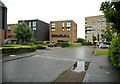
Cubes
Very regularly-shaped blocks of flats and apartments on London Avenue.
Image: © Richard Sutcliffe
Taken: 28 Jun 2023
0.04 miles
8
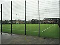
Football pitch
An all-weather football pitch beside Riverbank Primary School.
Image: © Richard Sutcliffe
Taken: 28 Jun 2023
0.05 miles
9
Clyde footbridge accessing Cuningar Loop Park
Image: © Gordon Brown
Taken: 14 Mar 2021
0.05 miles
10
Flats, London Avenue
The streets in the area of the former 2014 Commonwealth Games Athletes' Village are all named after Commonwealth cities.
Image: © Richard Sutcliffe
Taken: 28 Jun 2023
0.05 miles