IMAGES TAKEN NEAR TO
Summer Street, GLASGOW, G40 3TB
Introduction
This page details the photographs taken nearby to Summer Street, G40 3TB by members of the Geograph project.
The Geograph project started in 2005 with the aim of publishing, organising and preserving representative images for every square kilometre of Great Britain, Ireland and the Isle of Man.

There are currently over 7.5m images from over14,400 individuals and you can help contribute to the project by visiting https://www.geograph.org.uk
Image Map
Images are licensed for reuse under creativecommons.org/licenses/by-sa/2.0
Notes
- Clicking on the map will re-center to the selected point.
- The higher the marker number, the further away the image location is from the centre of the postcode.
Image Listing (195 Images Found)
Images are licensed for reuse under creativecommons.org/licenses/by-sa/2.0
Image
Details
Distance
1
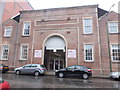
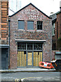
No 41 Broad Street
This large engineering works was built for Mavor and Coulson Ltd. by the architect Andrew Myles (c1841 - 1905). It cost £10,000 when built in 1896-7. Information from Bridgeton Heritage Trail, see http://www.glasgow.gov.uk/index.aspx?articleid=6210
Image: © Barbara Carr
Taken: 19 Mar 2013
0.04 miles
3
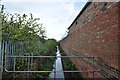
Camlachie Burn
A rare sighting of the Camlachie Burn.
Image: © Louise Harris
Taken: 16 Sep 2012
0.07 miles
4
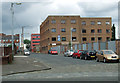
Broad Street, Glasgow
Office block with space to let on Broad Street. The old church to the left of picture was built in 1878, probably to the design of architect James K Dempster (died 1881). St Clement's Church of Scotland building was incorporated into the David Dale College in 1952-4 and served as the College gymnasium for many years, which probably saved it from demolition. The building is not listed. Information from Bridgeton Heritage Trail, see http://www.glasgow.gov.uk/index.aspx?articleid=6210
Image: © Barbara Carr
Taken: 19 Mar 2013
0.08 miles
6
Cycle lanes by London Road
Part of a network of cycle lanes which is springing up around the new Sir Chris Hoy Velodrome.
Image: © Thomas Nugent
Taken: 14 Jul 2012
0.09 miles
7
Frankie Miller Tribute
The security fence at Eastgate Image contains tributes to the history of Bridgeton and its people, including the singer and songwriter Frankie Miller http://www.frankiemiller.net/ .
The words form the shape of Miller's trademark bowler hat.
"I left my home
in Brigton town with all the
buildings falling down went to
seek my fortune went to seek my fame
all the folks I knew so well all the stories
fit to tell my ma said the boy child's got to
roam lord knows when I'll wend my way back
home well I wander here and I wander there I
wander almost everywhere got to find my baby
got to find my soul lord knows when I'll wend my
way back home though I'm not in trouble though
I'm not in pain each and every bar room get to look
the same I've been up all night just walking around
with all the places shutting down looking at the long
lost lonely souls lord knows when I'll wend my way back home
Frankie Miller"
Image: © Thomas Nugent
Taken: 7 Oct 2012
0.10 miles
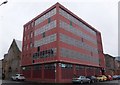
8
Olympia Street
The building with the flag is Olympia House, the Orange Order of Scotland HQ http://www.orangeorderscotland.com/home.html .
The white building on the left (Millers) has changed considerably since this photo was taken. See it in May 2014 Image
Image: © Thomas Nugent
Taken: 14 Jul 2012
0.10 miles
9
Old building on Olympia Street
Complete with ghost sign. Appears to be under renovation. The building was previously plastered and painted white with mock Tudor touches Image
Image: © Thomas Nugent
Taken: 17 May 2014
0.10 miles
10
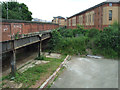
Bridgeton railway station
The remains of the trackbed and former island platform of the Glasgow Central Railway line to Newton can be seen on the London Road side of the station. London Road runs above the trackbed.
Image: © Thomas Nugent
Taken: 14 Jul 2012
0.10 miles