IMAGES TAKEN NEAR TO
Boden Street, GLASGOW, G40 3QF
Introduction
This page details the photographs taken nearby to Boden Street, G40 3QF by members of the Geograph project.
The Geograph project started in 2005 with the aim of publishing, organising and preserving representative images for every square kilometre of Great Britain, Ireland and the Isle of Man.

There are currently over 7.5m images from over14,400 individuals and you can help contribute to the project by visiting https://www.geograph.org.uk
Image Map (Loading...)


Getting Data...Please wait
Leaflet Map data © OpenStreetMap
Images are licensed for reuse under creativecommons.org/licenses/by-sa/2.0
Notes
- Clicking on the map will re-center to the selected point.
- The higher the marker number, the further away the image location is from the centre of the postcode.
Image Listing (95 Images Found)
Images are licensed for reuse under creativecommons.org/licenses/by-sa/2.0
Image
Details
Distance
1
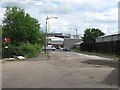
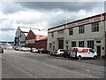
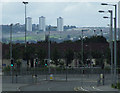
Bernard Street, Dalmarnock
Mostly empty sites now after deindustrialisation, but some units are still in production. A Commonwealth Games site is under construction in the background.
Image: © Richard Webb
Taken: 29 Jun 2011
0.07 miles
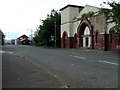
3
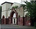
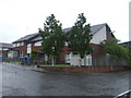
Church House Youth Club
Managed by Bridgeton St Francis Of The East Church of Scotland, in the former London Road East Church of Scotland building on Boden Street.
Image: © Thomas Nugent
Taken: 14 Jul 2012
0.09 miles
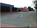
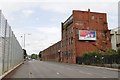
5

Possilpark Shotblasting Co Ltd, Dunn Street, Glasgow
Image: © Leslie Barrie
Taken: 14 Nov 2013
0.09 miles
8
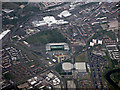
Parkhead from the air
Celtic Park dominates the scene, which also includes the Sir Chris Hoy velodrome, Emirates Arena, Parkhead Forge shopping centre, the Eastern Necropolis and Parkhead Cross.
See also Image
Image: © Thomas Nugent
Taken: 1 May 2017
0.12 miles
10
East End Regeneration Route
Looking south from London Road, with the Castlemilk towerblocks and St Margaret Mary's Secondary School on the hill in the distance.
Image: © Thomas Nugent
Taken: 14 Jul 2012
0.13 miles