IMAGES TAKEN NEAR TO
Arrol Place, GLASGOW, G40 3NY
Introduction
This page details the photographs taken nearby to Arrol Place, G40 3NY by members of the Geograph project.
The Geograph project started in 2005 with the aim of publishing, organising and preserving representative images for every square kilometre of Great Britain, Ireland and the Isle of Man.

There are currently over 7.5m images from over14,400 individuals and you can help contribute to the project by visiting https://www.geograph.org.uk
Image Map
Images are licensed for reuse under creativecommons.org/licenses/by-sa/2.0
Notes
- Clicking on the map will re-center to the selected point.
- The higher the marker number, the further away the image location is from the centre of the postcode.
Image Listing (159 Images Found)
Images are licensed for reuse under creativecommons.org/licenses/by-sa/2.0
Image
Details
Distance
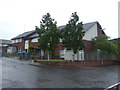
1
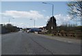
London Road at Parkhead Stadium
View looking West on London Road. Parkhead stadium on Photographer's right.
Image: © Gordon Dowie
Taken: 20 Apr 2010
0.01 miles
2
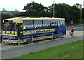
Midland Bluebird coach
On London Road, near Celtic Park.
Image: © Thomas Nugent
Taken: 14 Jul 2012
0.02 miles
3
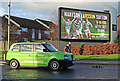
Green scene on London Road
A rare green taxi happened to pass this electronic billboard on London Road as the advert for the former Celtic players' event at the Hydro event was displayed.
Welshman John Hartson, Englishman Chris Sutton and Swede Henrik Larsson were a formidable strikeforce for Celtic in the early 2000s, scoring over 450 goals between them in domestic and European competitions.
Image: © Thomas Nugent
Taken: 28 Nov 2021
0.02 miles
4
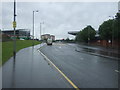
London Road (A74)
Looking east - Celtic Park on the left.
Image: © JThomas
Taken: 29 Jun 2017
0.03 miles
5

GEAR marker
The Glasgow Eastern Area Renewal (GEAR) project was a Government sponsored urban regeneration project in the mid 1970s to mid 1980s. The area lost some major heavy industries around that time with the closure of Beardmore's engineering works and the Arrol crane works.
There are several of these markers around the east end of the city. This one is on London Road, opposite the remains of Mauldslie Street.
Image: © Thomas Nugent
Taken: 7 Oct 2012
0.05 miles
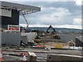
7
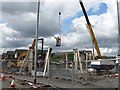
Construction, Parkhead
Probably part of the 2014 Commonwealth Games preparation.
Image: © Richard Webb
Taken: 29 Jun 2011
0.07 miles
8
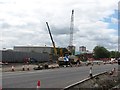
Road building, London Road
A new road under construction near Parkhead. This is part of the Commonwealth Games site.
Image: © Richard Webb
Taken: 29 Jun 2011
0.08 miles
9
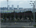
East End Regeneration Route
Looking south from London Road, with the Castlemilk towerblocks and St Margaret Mary's Secondary School on the hill in the distance.
Image: © Thomas Nugent
Taken: 14 Jul 2012
0.08 miles
10
Construction site off London Road
Commonwealth Games infrastructure under construction.
Image: © Richard Webb
Taken: 29 Jun 2011
0.09 miles